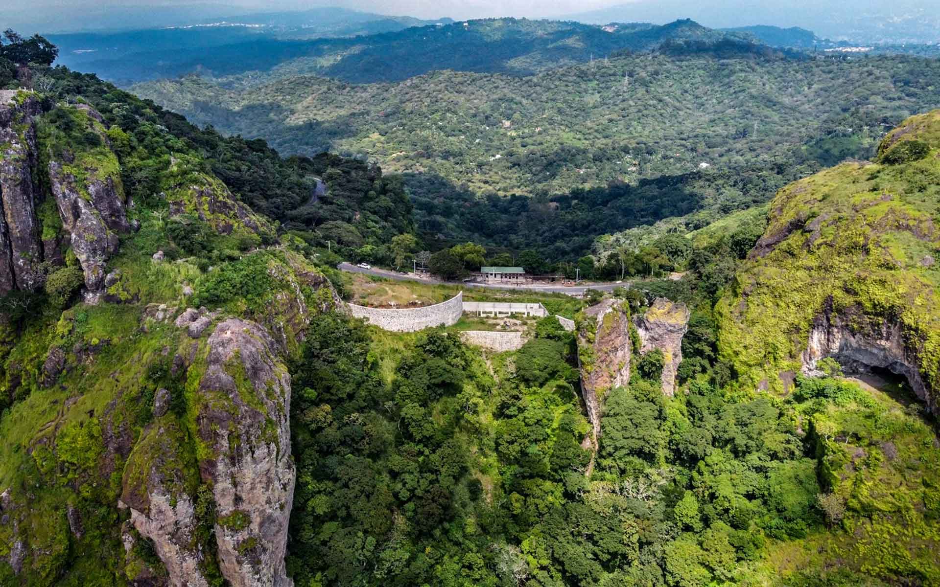
Aerial view of Puerta del Diablo showing the large volcanic landslide mega blocks forming the inverted relief ridge and tectonic viewpoint.
Geological Period
Lower Pliocene – Recent
Main geological interest
Geomorphology and active geological processes
Volcanology
Tectonics
Location
El Salvador, Central America.
13°37’26.0″N, 89°11’24.0″W
Aerial view of Puerta del Diablo showing the large volcanic landslide mega blocks forming the inverted relief ridge and tectonic viewpoint.
A TYPE INVERTED VOLCANIC LANDSLIDE MEGABLOCK DEPOSIT WITH AN OVERVIEW OF THE CENTRAL AMERICAN VOLCANIC ARC'S TECTONIC, VOLCANIC AND GEOMORPHOLOGIC EVOLUTION.
La Puerta del Diablo is a type locality for volcanic landslide blocks and matrix, where the major textural and structural elements are well exposed and accessible in a small area, allowing the kinematics of such huge events to be observed in detail. In addition, Puerta el Diablo is a prime example of volcanic inverted topography, a valley-confined landslide that has become a ridge. The dominating topography in turn allows a wide overview of the highly diverse surrounding volcano-tectonic geomorphology, where the plate tectonic evolution of Central American Volcanic Arc can be read clearly in the landscape.
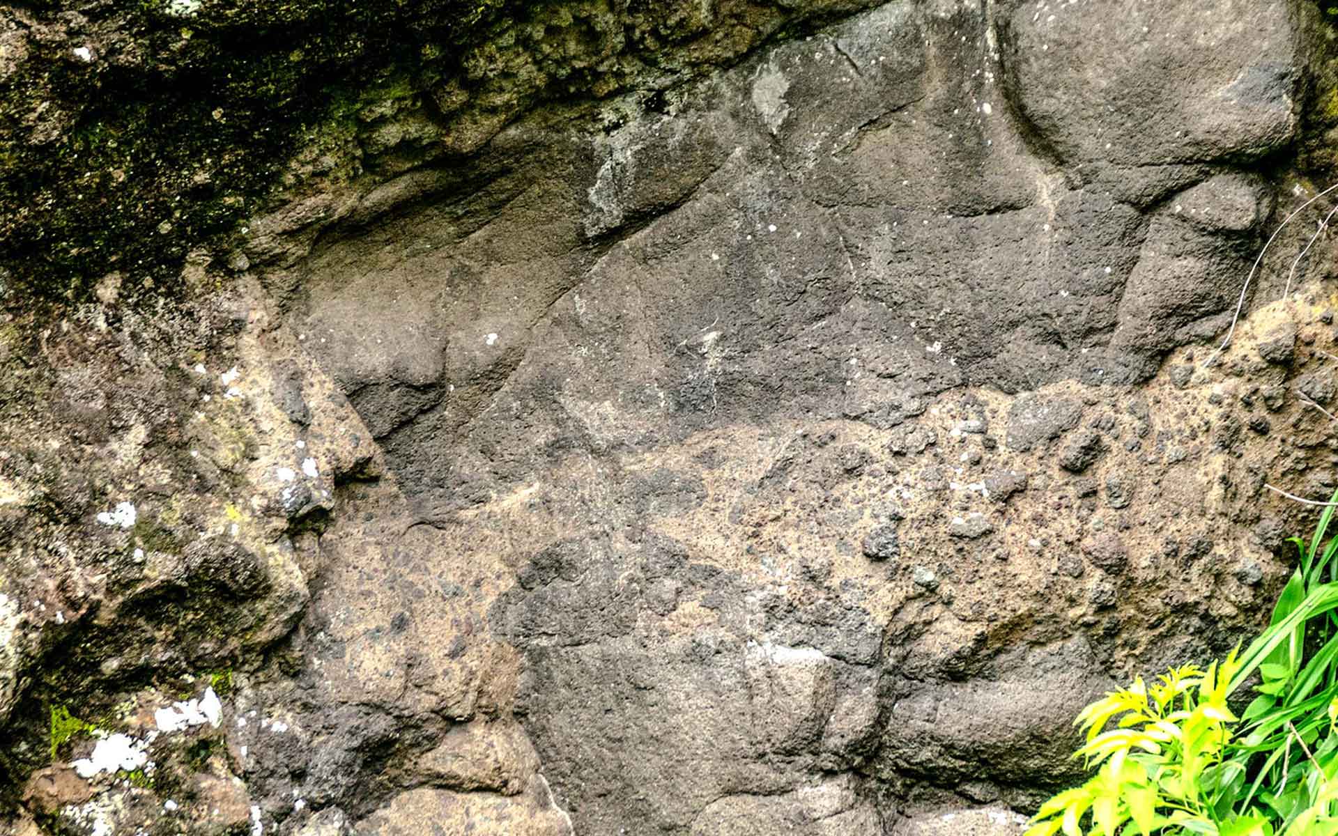
Close up view of outcrop (6m across) of the volcanic landslide block and matrix facies contacts, with injected breccia in one large lava megablock.
Geological description
La Puerta del Diablo is a debris avalanche deposit with megablocks. The 100 m wide blocks stand out as cliffs surrounded by weaker landslide matrix. The blocks, their structures and their mechanical interaction with the matrix are well exposed in roadcuts and natural outcrops, providing a type example of the interior textures and structure of a volcanic landslide, with classic breccias, jig-saw crack textures, and block interactions.
The resistant deposit forms a high inverted relief ridge perched above the heavily faulted and eroded Pleistocene Panchimalco Caldera. The landslide lies on a full stratovolcano sequence of the coastal El Bálsamo range of volcanoes.
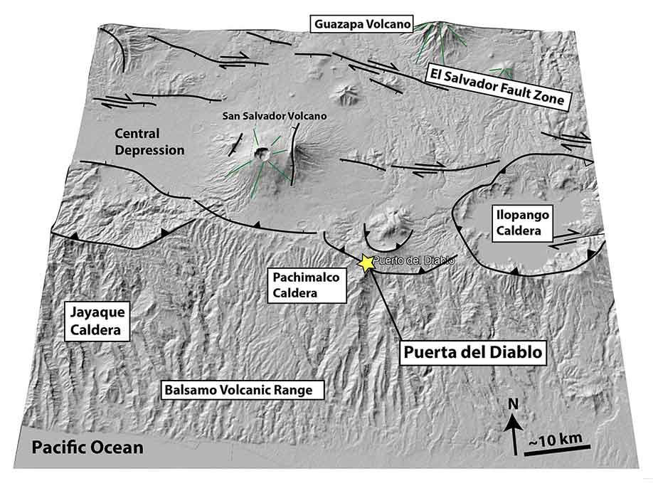
The high ridge afford a 360 degree panorama of the tectonics, volcanism, and geomorphology of the Central American volcanic arc. This includes the Pacific volcanic slope, the southern and northern rims of the central rift, rifted calderas (e.g., Jayaque, Panchimalco, La Carbonera, Ilopango) (Lexa et al., 2011, Hernández and Jicha, 2019; Jicha and Hernández, 2022) and faulted volcanoes (e.g.. San Salvador). The landscape displays the effects of subduction steepening followed by strike-slip tectonics. Poet Raúl Contreras named Puerta del Diablo in 1951, although it was known in 1762 for seismic and rain triggered-collapse of some megablocks (Lardé and Larín, 2000).
Scientific research and tradition
Conditions in El Salvador have not allowed research until recently. The outcrops of the landslide blocks are exemplary, and their formation and setting are highly significant. In addition, the viewpoint has been long used for geodynamic overviews of the Central American arc (Sapper, 1937; Williams and Mayer-Abich, 1955).
Oblique view of the Puerta del Diablo vistas, showing the central depression, calderas, faults and coastal ranges of the volcanic arc in El Salvador.
Jicha, B.R. and Hernández, W. (2022) ‘Effusive and explosive eruptive history of the Ilopango caldera complex, El Salvador’, Journal of Volcanology and Geothermal Research, 421, p. 107426. Available at: https://doi.org/10.1016/j.jvolgeores.2021.107426.
Lardé y Larín, J. (2000) El Salvador: Inundaciones e incendios, erupciones y terremotos. 2a. ed. San Salvador: Consejo Nacional para la Cultura y el Arte, Dirección de Publicaciones e Impresos (Biblioteca de Historia Salvadoreña, 5).
Lexa, J. et al. (2011) ‘Geology and volcanic evolution in the southern part of the San Salvador Metropolitan Area’, Journal of Geosciences, 56(1), pp. 106–140. Available at: https://doi.org/10.3190/jgeosci.088.
Lexa, J. et al. (2021) ‘Geología del Área Metropolitana de San Salvador (1:50 000), El Salvador’, Revista Geológica de América Central, pp. 1–23. Available at: https://doi.org/10.15517/rgac.v66i0.49972.
Sapper, K. (1937) Mittelamerika. Handbuch der Regionalen Geologie. Winters Universtätsbuchhandlung, Heidelberg.
Williams, H. and Meyer-Abich, H. (1955) Volcanism in the southern part of El Salvador: with particular reference to the collapse basins of Lakes Coatepeque and Ilopango. Berkeley: University of California Press.
Author(s)
Walter Hernandez
Universidad de El Salvador, Ciudad Universitaria, San Salvador, El Salvador