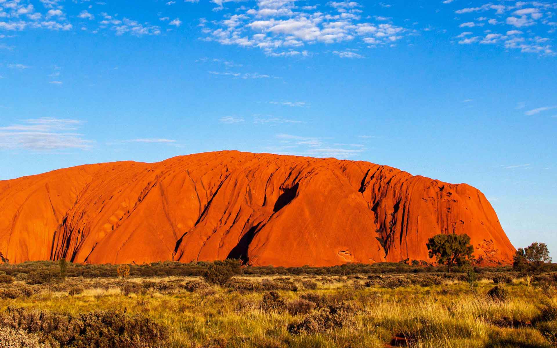
Massive sandstone inselberg (a prominent isolated residual knob that rises abruptly from and surrounded by extensive flat lowlands). (Image credit: Andy Selinger / Alamy Stock Photo).
Geological Period
Precambrian (Ediacaran)
Main geological interest
Geomorphology and active geological processes
Location
Uluru-Kata Tjuta National Park World Heritage site. Northern Australia.
25°20’40.0″S, 131°02’08.0″E
Massive sandstone inselberg (a prominent isolated residual knob that rises abruptly from and surrounded by extensive flat lowlands). (Image credit: Andy Selinger / Alamy Stock Photo).
The most well-known massive sandstone monolith/inselberg in the world constituting a fundamental landform in the traditional belief of Aboriginal people.
Uluru, as part of the Uluru-Kata-Tjuta National Park, was added to the UNESCO World Heritage List in 1987. Uluru is one of the largest and best known inselbergs in the world. Unlike many other inselbergs that are erosionally developed from cratons and composed of granite or gneiss or both, Uluru is composed of vertically dipping bedded arkose (feldspathic sandstone). In 1994, UNESCO recognised the cultural landscape and the unique relationship between the natural environment and the belief system of Anangu people (one of the oldest human societies on Earth). Uluru is globally unique because of its size and shape, combined with its composition.
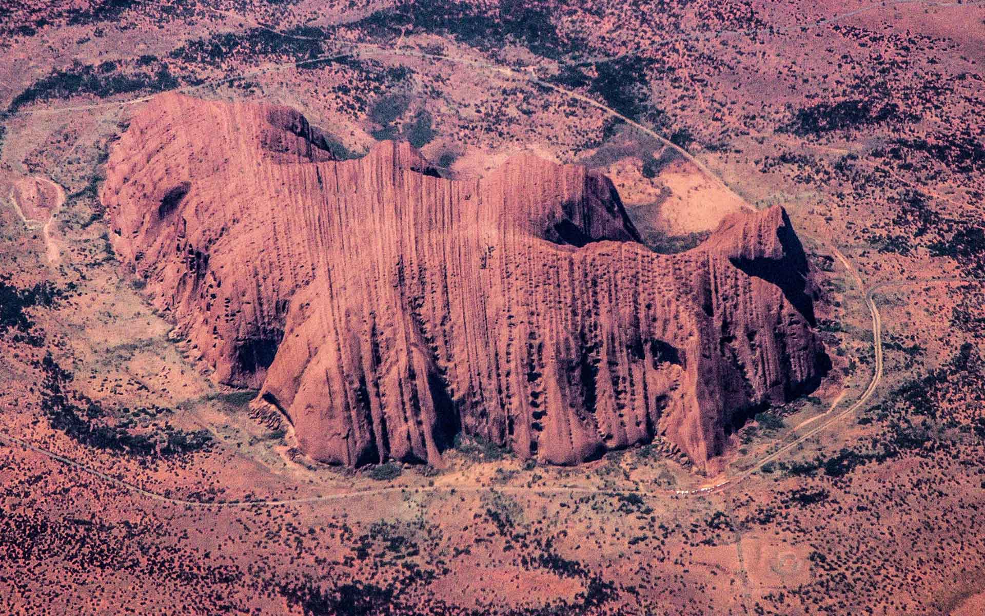
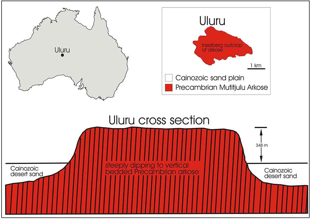
Uluru (Pitjantjatjara: Uluru, also known as Ayers Rock (Sweet and Crick, 1994; Twidale and Bourne, 2012), is a large sandstone formation in the centre of Australia. It is in the southern part of the arid Northern Territory. Uluru, a massive inselberg or ‘island mountain’ of bedded sandstone referred to the Mutitjulu Arkose, is a prominent isolated residual knob that rises abruptly from and surrounded by extensive flat lowlands. The remarkable feature of Uluru is its lack of jointing and parting at bedding surfaces, leading to the lack of scree slopes and soil (Figures 2 and 3). Uluru is dominantly composed of coarse-grained arkose (a sandstone characterised by abundant feldspar) and some conglomerate, and is Precambrian, some 550 million years old. The minerals present suggest derivation predominantly from a granite source. Weathering of iron-bearing minerals gives the outer surface layer of rock a red-brown rusty colour. Sedimentary features within the sandstone include cross-bedding and ripples, analysis of which indicates deposition from broad shallow high energy fluvial channels and sheet flooding (Young et al., 2002).
Scientific research and tradition
From an Aboriginal perspective, Uluru was created at the beginning of time by spirit people (Isaacs, 1980). Early investigators interpreted Uluru as the residual after long-distance scarp retreat or scouring by the elements. More recent investigators, largely by Twidale, found that the inselberg developed by the lowering of the surrounding plains (Sweet and Crick, 1994; Twidale and Bourne, 2012).
Geology of Uluru showing its location in Australia, its plan form, and cross-section bordered by Cainozoic desert sand plain.
Reference
Brocx, M. and Semeniuk, V. (2007) ‘Geoheritage and geoconservation – History, definition, scope and scale’, Journal of the Royal Society of Western Australia, 90, pp. 53–87.
Isaacs, J. (1980) Australian Dreaming: 40,000 Years of Aboriginal History. Lansdowne Press.
Northern Territory Government (no date) Place Names Register, Place Names Register Extract: Uluru / Ayers Rock. Northern Territory Place Names Register. Available at: http://www.ntlis.nt.gov.au/placenames/view.jsp?id=10532.
Sweet, I.P. and Crick, I.H. (1994) Uluru & Kata Tjuta: a geological history. (Monograph). Canberra: Australian Geological Survey Organisation.
Twidale, C.R. and Bourne, J.A. (2012) ‘Contrasted Perceptions of Uluru’, Physical Geography, 33(3), pp. 285–302. Available at: https://doi.org/10.2747/0272-3646.33.3.285.
Young, D.N. et al. (2002) ‘Ayers Rock, Northern Territory, Map Sheet GS52-8 (2nd edition) (Map). 1:250 000’. (Northern Territory Geological Survey. Geological Map Series Explanatory Notes.).
Author(s)
Margaret Brocx
Adjunct Professor of Research|College of Science, Health, Engineering and Education, Discipline Environmental and Conservation Sciences. Murdoch University, Western Australia, Australia
Vic Semeniuk
Adjunct Professor of Research|College of Science, Health, Engineering and Education, Discipline Environmental and Conservation Sciences. Murdoch University, Western Australia, Australia