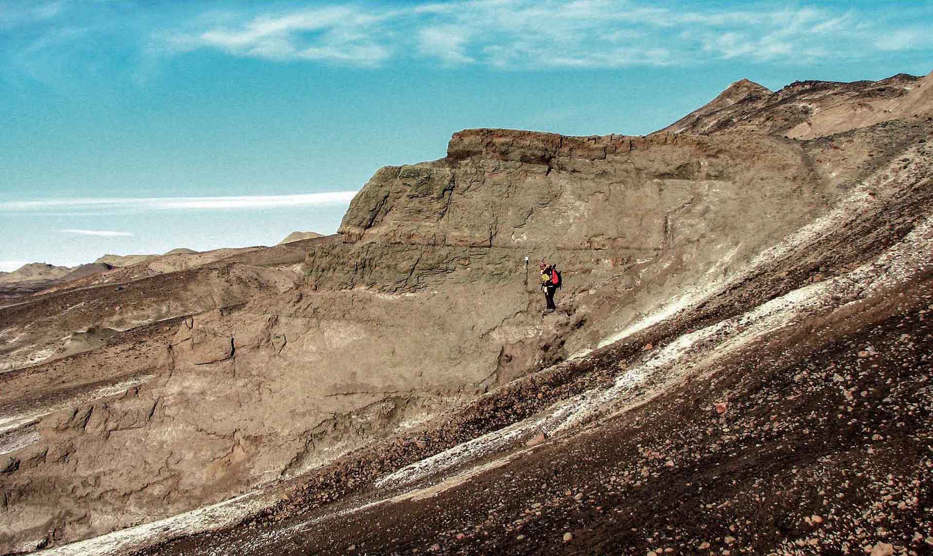
Photograph showing the K-Pg boundary at the site of the iridium anomaly identification.
The most representative high latitude K-PG boundary location and one of the most significant and best exposed globally.
The location represents one of the best sites globally for the study of the K-Pg global mass extinction event. The exposure is exceptional and continuous. The site has been subject to substantial international research. It is a key southern hemisphere site for the study of palaeontology, biostratigraphy, geochemistry and magnetostratigraphy. The location contains evidence that the K-Pg extinction in the high latitudes was just as extensive as in lower latitude sites closer to the asteroid impact site. Extensive geological mapping and many books and research articles have been published in scientific journals (Feldmann and Woodburne, 1988; Francis et al., 2006).
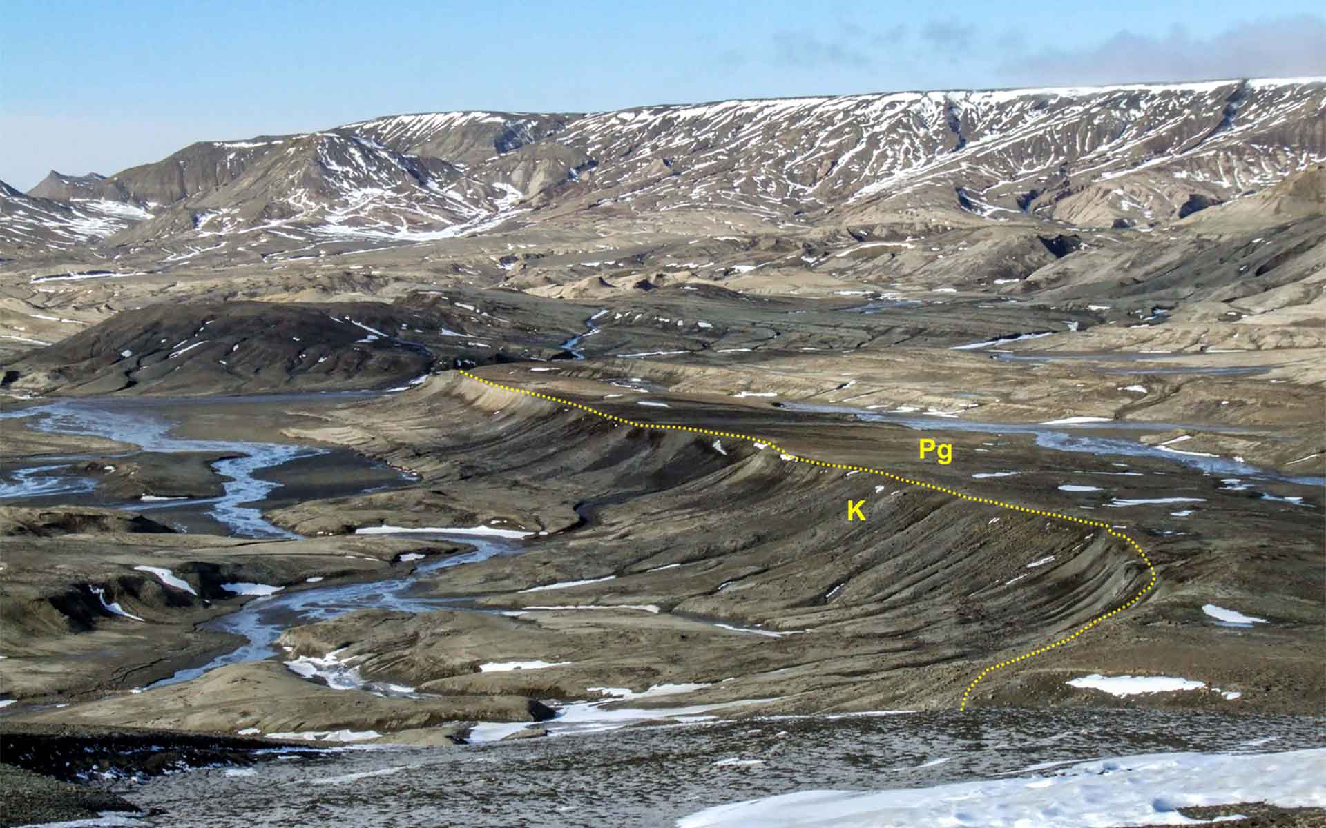
The Cretaceous (K)-Paleogene (Pg) boundary at the northern end of its area of outcrop on Seymour (Marambio) Island.
Geological description
The Site encompasses the K-Pg boundary and the upper part of the López de Bertodano Formation, Seymour Island Group (late Maastrichtian-early Danian age). The boundary zone considered for this Geosite is c. 7 km long and c. 1.8 km wide (c. 13 km2 ).
The well documented stratigraphic section where the iridium anomaly was first identified (Elliot et al., 1994) is located adjacent to Blackrock Ridge (Filo Negro) (coordinates: 64° 17’ 24” S; 56° 44’ 30” W). The glauconite-bearing sandstone interval is easily recognized across the southwestern part of the island. Visibility of the site is excellent, and it is easily identified in the field because of the adjacent basalt dyke.
In the northern sector of the K-Pg boundary is where the boundary was first defined palaeontologically (coordinates: 64° 16’ 07” S; 56° 42’ 37” W). There is an exceptional three-dimensional exposure, with little surface cover and ice-free, lateral continuity over several kilometres and including a rare combination of fossils from many different groups (invertebrates, vertebrates, plants, microfossils, etc.) (Acosta Hospitaleche et al., 2019, Montes et al., 2019)
Scientific research and tradition
This is the only confirmed onshore locality showing an extensive K-Pg transition in Antarctica. It contains the first locality where the iridium anomaly was identified in Antarctica and is a locality for key reference fossil collections.
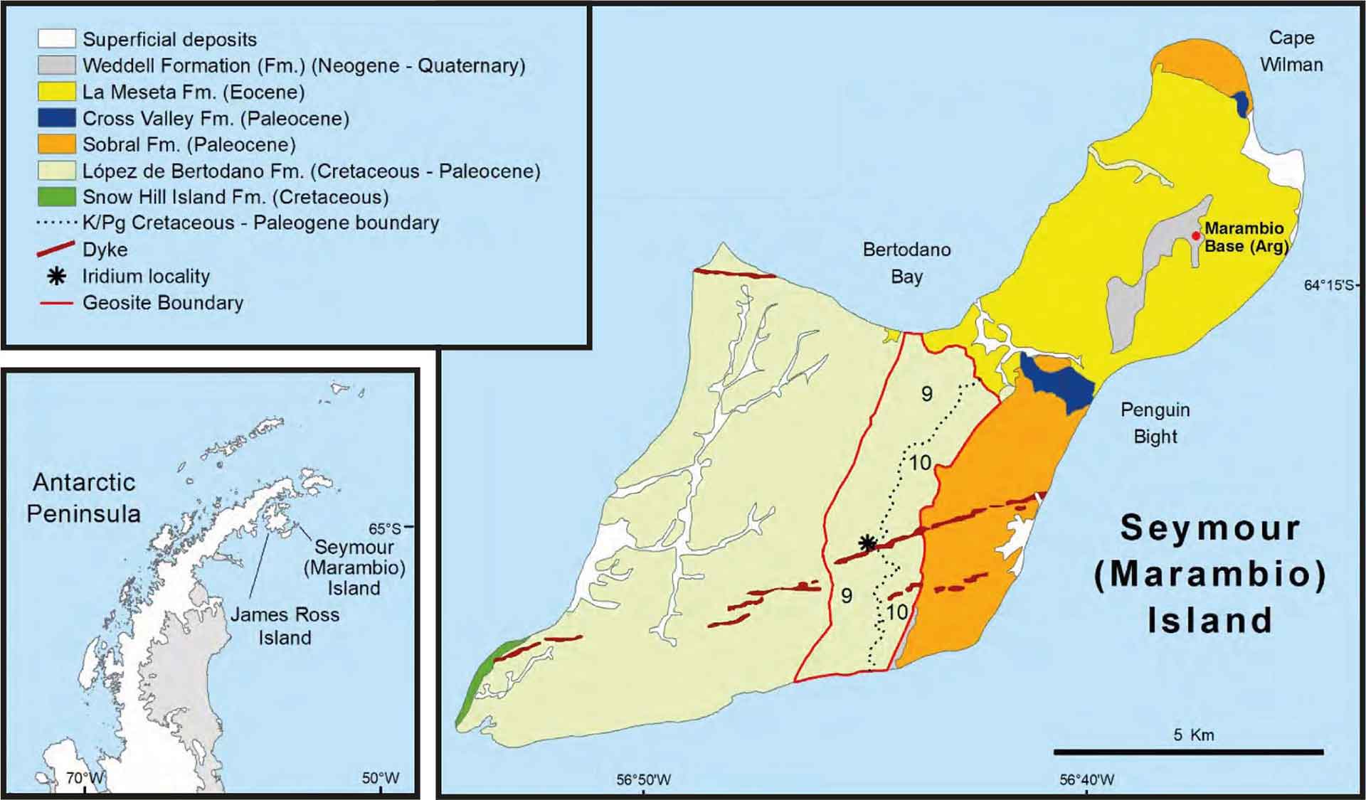
Simplified geological map of Seymour (Marambio) Island showing the Geosite boundary outlined in red. The K-Pg boundary and mapping units 9 and 10 are shown.
Reference
Acosta Hospitaleche, C., Gelfo, J.N. and Crame, J.A. (2019) Geology and Paleontology of the James Ross Basin, Antarctic Peninsula. (Advances in Polar Sciences, 30).
Elliot, D.H. et al. (1994) ‘Iridium and dinocysts at the Cretaceous-Tertiary boundary on Seymour Island, Antarctica: Implications for the K-T event’, Geology, 22(8), pp. 675–678. Available at: https://doi.org/10.1130/0091-7613(1994)022<0675:IADATC>2.3.CO;2.
Feldmann, R.M. and Woodburne, M.O. (eds) (1988) ‘Geology and Paleontology of Seymour Island Antarctic Peninsula’, Geological Society of America Memoir, 169, p. 566. Available at: https://doi.org/10.1130/MEM169.
Francis, J.E., Pirrie, D. and Crame, J.A. (2006) ‘Cretaceous–Tertiary High-Latitude Palaeoenvironments, James Ross Basin, Antarctica’, Geological Society Special Publication, (258), p. 206. Available at: https://doi.org/10.1017/S0016756807003640.
Montes, M. et al. (eds) (2019) Geología y geomorfología de Isla Marambio (Seymour). Acompañado de mapas, E 1:20.000. 1st edition. Madrid-Instituto Geológico y Minero de España; Buenos Aires-Instituto Antártico Argentino (Serie Cartográfica Geocientífica Antártica).
Author(s)
Luis Carcavilla
Geological Survey of Spain (IGME), Madrid, Spain
Alistair Crame
British Antarctic Survey, Cambridge, United Kingdom
Enrique Díaz-Martínez
Geological Survey of Spain (IGME), Madrid, Spain
David H. Elliot
Ohio State University, Columbus, United States
Jane Francis
British Antarctic Survey, Cambridge, United Kingdom
Kevin A. Hughes
British Antarctic Survey, Cambridge, United Kingdom
Jerónimo López-Martínez
Universidad Autónoma de Madrid, Spain
Manuel Montes
Geological Survey of Spain (IGME), Madrid, Spain
Marcelo Reguero
Universidad Nacional de La Plata y Instituto Antártico Argentino, Buenos Aires, Argentina