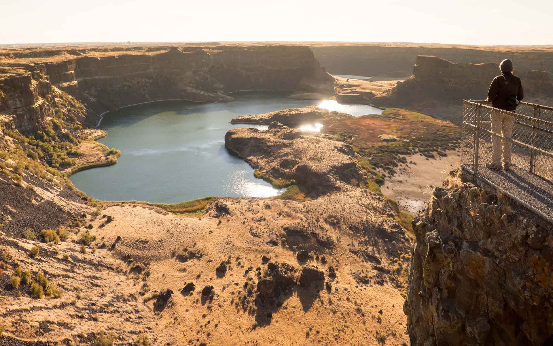
A panoramic view of the 400-foot (122-meter) high cliffs and waterfall plunge pools of Dry Falls from the state park visitor center. (Photo Credit: Daniel Coe, Washington Geological Survey).
Geological Period
Pleistocene
Main geological interest
Geomorphology and active geological processes
Location
Columbia Basin / Washington State, USA.
47°36’23.0″N, 119°21’53.0″W
A panoramic view of the 400-foot (122-meter) high cliffs and waterfall plunge pools of Dry Falls from the state park visitor center. (Photo Credit: Daniel Coe, Washington Geological Survey).
THE DRY REMNANTS OF ICE AGE WATERFALLS THAT MAKE UP ONE OF THE LARGEST CATARACTS ON THE PLANET.
The debate surrounding the origin of Dry Falls and the Channeled Scabland has had a significant impact on our understanding of basic geologic principles. When J Harlan Bretz first proposed in 1923 that huge floods had shaped the landscape of eastern Washington, his hypothesis was rejected as not conforming to the current assumptions of uniformitarianism. This principle assumes that geologic processes have occurred gradually in the past, just as they do in the present. As evidence continued to build for a glacial flood origin, the scientific community eventually accepted that catastrophic events can punctuate periods of slower geologic evolution.
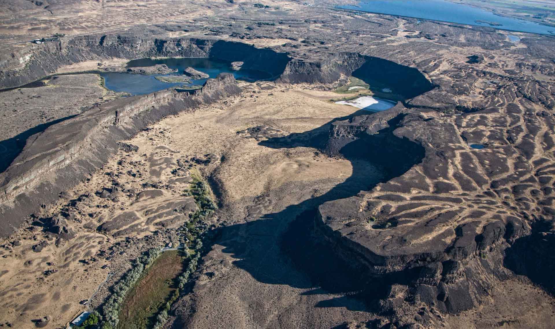
An aerial view of Dry Falls, showing the steep cliffs of the cataract and the waterfall plunge pools now filled with groundwater. (Photo Credit: Bruce Bjornstad).
Geological description
Dry Falls, the main feature in a series of huge cataracts known as the “great cataract group”, sits at the heart of Washington’s Channeled Scabland, a vast landscape of dry canyons scoured out by glacial outburst floods at the end of the last ice age. Tall cliffs and plunge pools tell the story of this waterfall estimated to have been several times larger than Niagara Falls and a key piece of evidence that massive floods had scoured this area. The history of the Channeled Scabland starts in the late Pleistocene, as ice sheets in the Columbia River Basin began to melt. The ice dam holding back glacial Lake Missoula in northern Idaho and western Montana collapsed and released a cataclysmic surge of water estimated to have been ten times the flow of all the rivers in the world. The floodwaters carved out deep canyons, known as coulees, into the thick stacks of Miocene basaltic lava flows that cover nearly one third of Washington. These lava flows, known as the Columbia River Basalt Group, are riddled with cooling cracks and crumbly flow tops. These properties made it possible for the huge floods to erode the rocks into this unique landscape.
Scientific research and tradition
Research on the origins of the Channeled Scabland has been going on for almost a century, starting with the fundamental work of J Harlan Bretz in the 1920s. The debate has resulted in hundreds of publications on the topic, both in the scientific literature and in popular science.
Map of the Missoula floods at their maximum extent, highlighting the vast Channeled Scabland terrain, with its network of coulees eroded into basaltic lava flows. (Image Credit: Daniel Coe, Washington Geological Survey).
Bjornstad, B.N. (2021) Ice Age Floodscapes of the Pacific Northwest: A Photographic Exploration. Springer Nature.
Bretz, J.H. (1923) ‘The Channeled Scablands of the Columbia Plateau’, The Journal of Geology, 31(8), pp. 617–649. Available at: https://doi.org/10.1086/623053.
Bretz, J.H. (1959) ‘Washington’s channeled scabland.’, Washington Division of Mines and Geology Bulletin, 45, p. 59.
U.S. Geological Survey (1973) The channeled scablands of eastern Washington : the geologic story of the Spokane flood. U.S. Geological Survey, p. 23. Available at: https://doi.org/10.3133/70007447.
Author(s)
Susan Schnur
Washington Geological Survey, Washington State Department of Natural Resources, Washington, USA
Ryan Karlson
Washington State Parks and Recreation Commission, Washington, USA