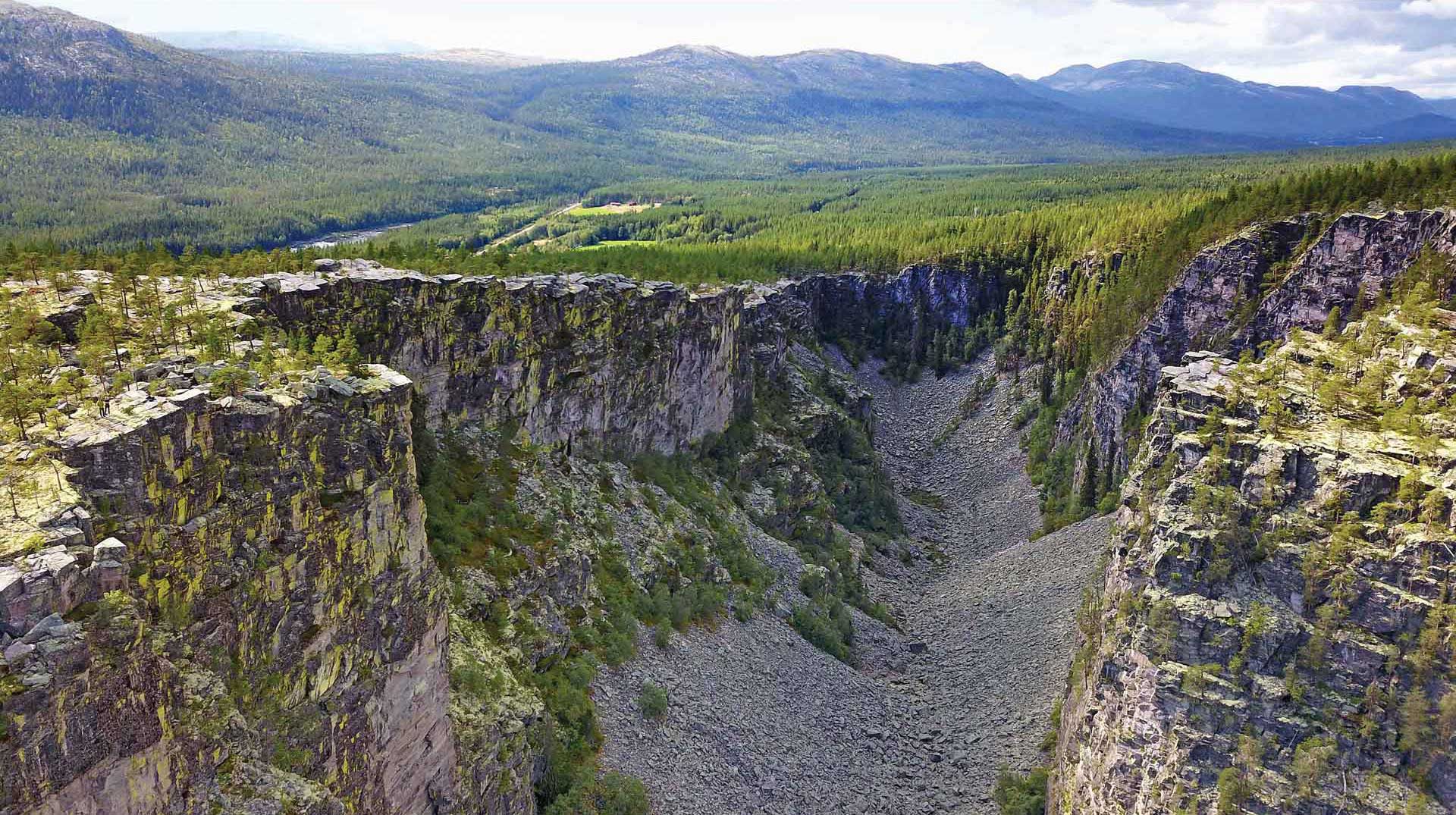
Jutulhogget (“cut by trolls”) canyon was incised in the Precambrian sandstone as flood waters drained from Østerdalen valley to Rendalen valley during a glacial lake outburst flood. View towards Østerdalen in the west. Note the people on the left hand side of the image.
Geological Period
Quaternary / Holocene
Main geological interest
Geomorphology and active geological processes
Location
Alvdal and Rendalen municipalities, Innlandet Country, Norway.
61°59’59.0″N, 10°54’27.0″E
Jutulhogget (“cut by trolls”) canyon was incised in the Precambrian sandstone as flood waters drained from Østerdalen valley to Rendalen valley during a glacial lake outburst flood. View towards Østerdalen in the west. Note the people on the left hand side of the image.
A LARGE CANYON CREATED BY A DRAMATIC ICE AGE FLOOD.
The site has been subject to research since 1880s and is a reference area for understanding glacial retreat and glaciofluvial processes. Early scientific discussions debated different explanations not only about the canyon but also on former shorelines and moraines. Ongoing research is revealing new knowledge and understanding of the complexity in such processes especially based upon deposition in the areas connected to the glacial lake and the catchment area. Besides, the area is easily accessible for visitors – to admire and learn.
The steep walls along the Jutulhogget canyon are unstable, and the canyon floor is draped by a thick layer of scree material. The canyon walls are now home for rare types of lichens.
Geological description
Jutulhogget canyon, 2.5 km long, 150- 300 meters wide and up to 240 meters deep, is an impressive and striking landscape feature. It is the result of a dramatic event during the final demise of the Scandinavian Ice Sheet at the end of the last Ice Age. As the ice sheet retreated across the main drainage divide, meltwater was dammed between local spillways and the receding ice margin. A big glacial lake – “Nedre Glomsjø” – formed in Østerdalen valley, covering a 1350 km2 large area, holding 140 km3 of water (about three times the size of Norway’s largest lake Mjøsa). When the glacier dam broke a catastrophic outburst flood (jökulhlaup) funneled southward beneath the remnant ice sheet. As the ice-dam collapse occurred in Rendalen, a large amount of water had to drain eastward from Østerdalen, leading to vast erosion and formation of the huge Jutulhogget canyon over a short period of time. The basement rock of Precambrian sandstone forms a huge thrust sheet related to the Caledonian orogeny. Weakened by old tectonic stress, it broke apart and was transported and re-deposited far downstream by the outburst flood. The gigantic boulders located downstream of the canyon tells a tale of the extreme energy involved during such outburst floods.
Scientific research and tradition
The first scientific publications, mainly in Norwegian publications created a strong debate on the mechanisms and processes able to create such features. New tools, such as LIDAR, now provide a new understanding of the complexity of the processes and the depositions connected to the lake, the jökulhlaup and the depositions.
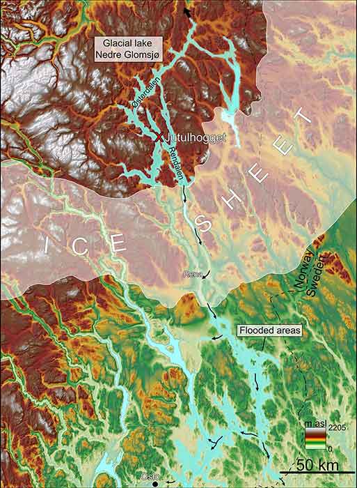
Map showing the location of Jutulhogget canyon; extent of glacial lake Nedre Glomsjø, the remnant ice sheet and areas south of the ice sheet inundated during the outburst flood.
Reference
Berthling, I. and Sollid, J.L. (1999) ‘The drainage history of glacial lake Nedre Gl msj, southern Central Norway’, Norsk Geografisk Tidsskrift – Norwegian Journal of Geography, 53(4), pp. 190–201. Available at: https://doi.org/10.1080/002919599420785.
Høgaas, F. and Longva, O. (2016) ‘Mega deposits and erosive features related to the glacial lake Nedre Glomsjø outburst flood, southeastern Norway’, Quaternary Science Reviews, 151, pp. 273–291. Available at: https://doi.org/10.1016/j.quascirev.2016.09.015.
Høgaas, F. and Longva, O. (2018) ‘The early Holocene ice-dammed lake Nedre Glomsjø in Mid-Norway: an open lake system succeeding an actively retreating ice sheet’, Norsk Geologisk Tidsskrift [Preprint]. Available at: https://doi.org/10.17850/njg98-4-08.
Holmsen, G. (1915) Brædæmte sjøer i nordre Østerdalen. Kristiania: Aschehoug (komm.) (Norges geologiske undersøkelse, 99-0119969-7 ; 73).
Longva, O. (1994) Flood Deposits and Erosional Features from the Catastrophic Drainage of Preboreal Glacial Lake Nedre Glåmsjø, SE Norway. PhD Thesis. University of Bergen, Department of Geology.
Author(s)
Kristin Rangnes
General manager/Geologist, Gea Norvegica UNESCO Global Geopark
Fredrik Høgaas
Scientist, Geological Survey of Norway
Rolv Magne Dahl
Scientist, Geological Survey of Norway