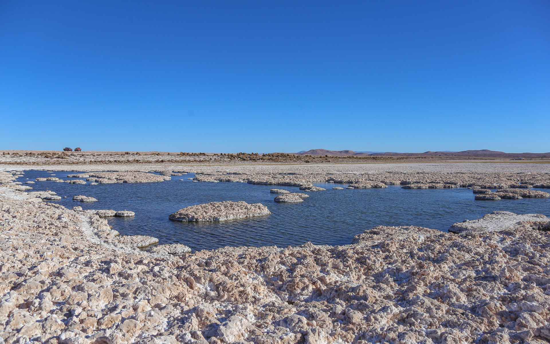
The Puquios are natural depressions where subterranean water come to the surface at the western part of Atacama desert, the most arid of the world (by Sernageomin).
Geological Period
Pleistocene-Holocene
Main geological interest
Geomorphology and active geological processes
Geobiology
The Puquios are natural depressions where subterranean water come to the surface at the western part of Atacama desert, the most arid of the world (by Sernageomin).
MICROBIAL MATS ON THE BRINE LAGOONS OF THE ATACAMA DESERT SIMILAR TO THE FIRST ORGANISMS INHABITING THE EARTH.
The Puquios de Llamara is one of the driest and most irradiated environments of Earth, and from the biodiversity studies it has been proposed as analogous to the primitive Earth (Gutiérrez-Preciado et al., 2018). The microbial mats, evaporitic domes and their metabolic transitions recapitulate what happened during the great oxygenation event, that is, when cyanobacteria began to produce oxygen 2.5 billion years ago (Gutiérrez-Preciado et al., 2018). These poly-extreme environments open a universe of possibilities to elucidate these ancient metabolic pathways that provide critical information about early life in extreme environments (Farías et al., 2017).
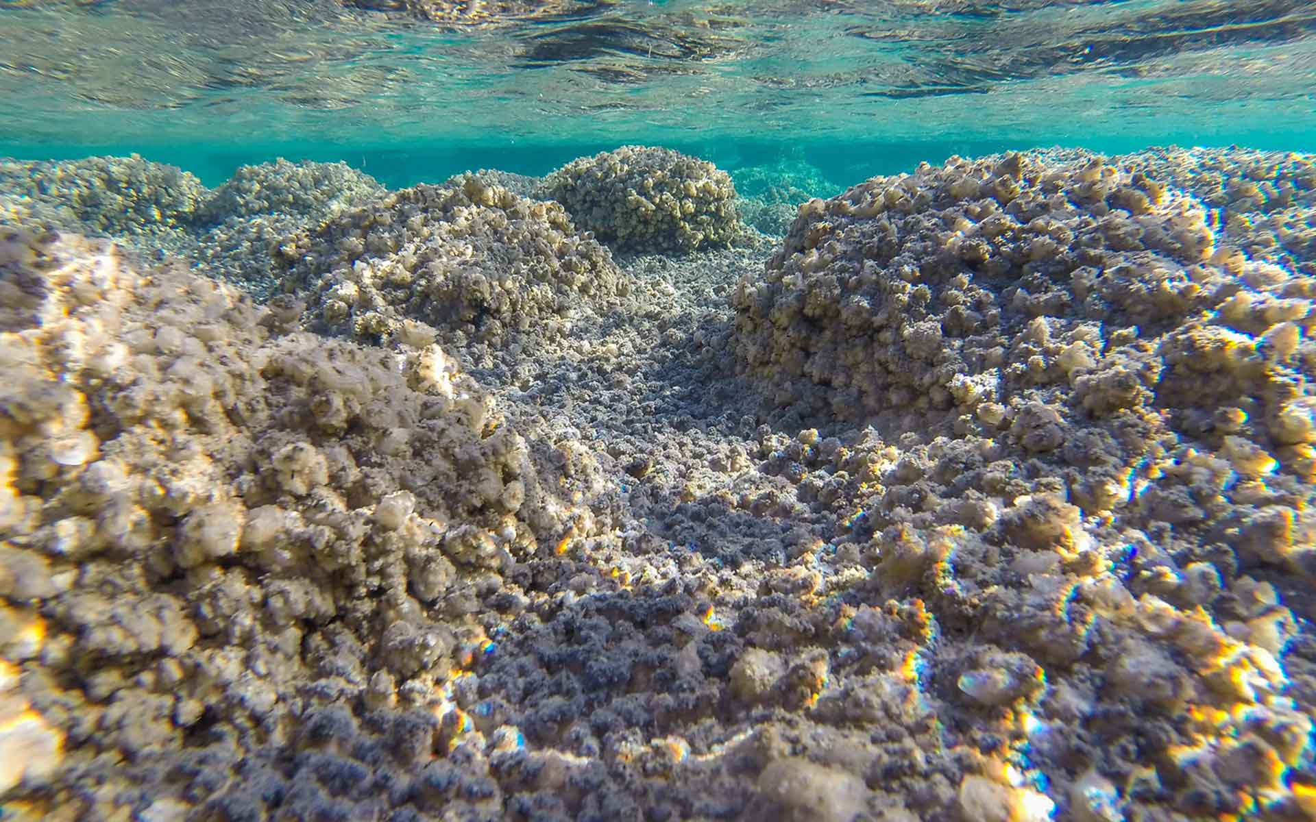
Subaquatic photo of microbial mats of cyanobacteria and sulphate minerals creating evaporitic domes within the ponds (by Sernageomin).
Geological description
The Llamara salt flat is made up of salt crusts and smaller amounts of fine sediment. Among the most common salts are sulfates (gypsum, anhydrite), carbonates, nitrates and halides (common salt) that form a superficial crust (Vásquez et al., 2018), associated with deep groundwater, from the Pampa del Tamarugal aquifer. In the Puquios, the chemical analysis of these waters shows that there is a predominance of sulfates and dissolved sodium in them, although in some sectors chlorine or bicarbonate, and magnesium or calcium also predominate, especially towards the southwest of the salt flat (López et al., 2017). Geological and climatic conditions have allowed the development of microbial mats of cyanobacteria and other organisms and of microbial structures like evaporitic domes (stromatolites). Microbial mats are laminated structures, which are controlled by environmental factors such as light, temperature, salinity, dissolved oxygen, and the presence of sulfides. These laminations have different colorations as a result of the development of photosynthetic bacteria that contain photosynthetic pigments and, therefore, different patterns of available light (Farías et al., 2017). The evaporitic domes occur where microorganisms form aggregates occupying the pore spaces inside halite, where microbial interactions occur (Farías et al., 2017).
Scientific research and tradition
The Puquios of the Llamara salt flat has been studied by various specialists in geology, hydrogeology, salt deposits, mineral resources (saline deposits) and biology.
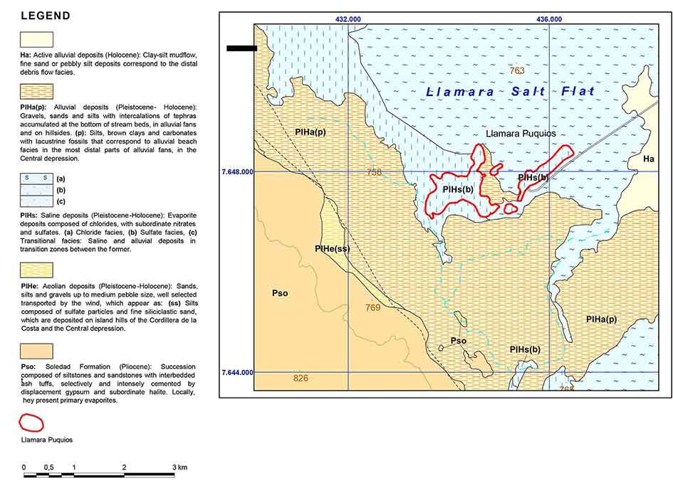
Extract of the Guanillos of the north and Llamara salt flat geological map (modified of Vásquez et al., 2018).
Reference
Farías, M. (2020) Microbial Ecosystems in Central Andes Extreme Environments Biofilms, Microbial Mats, Microbialites and Endoevaporites. Switzerland: Springer Nature. Available at: https://doi.org/10.1007/978-3-030-36192-1.
Gutiérrez-Preciado, A. et al. (2018) ‘Functional shifts in microbial mats recapitulate early Earth metabolic transitions’, Nature Ecology & Evolution, 2(11), pp. 1700–1708. Available at: https://doi.org/10.1038/s41559-018-0683-3.
López, L. et al. (2017) Hydrogeology of the Pampa del Tamarugal Basin, Tarapacá Region. Santiago, Chile: Sernageomin (National Service of Geology and Mining, Geological Chart of Chile, Hydrogeology Series, 6). Available at: https://snia.mop.gob.cl/repositoriodga/handle/20.500.13000/4393.
López, P. et al. (1999) ‘Geochemical characteristics and evolution patterns of the surface brines of the Salar de Llamara, Chile’, Geological Magazine of Chile, pp. 89–108.
Solari, M. (2015) ‘The unexplored geobiological heritage of Chile: key to understand the past and future’, in Chilean Geological Congress, No. 14, Abstracts 3. La Serena, pp. 388–391.
Vásquez, P. et al. (2018) Guanillos del Norte and Salar de Llamara Charts, Regions of Tarapacá and Antofagasta. (SERNAGEOMIN. Geological Chart of Chile, Basic Geology Series, nº195-196 (Original in spanish)).
Author(s)
Felipe Cristian Fuentes Carrasco Hydrogeology and Geoheritage units. Department of Applied Geology and Geological Resources, National Service of Geology and Mining, Chile