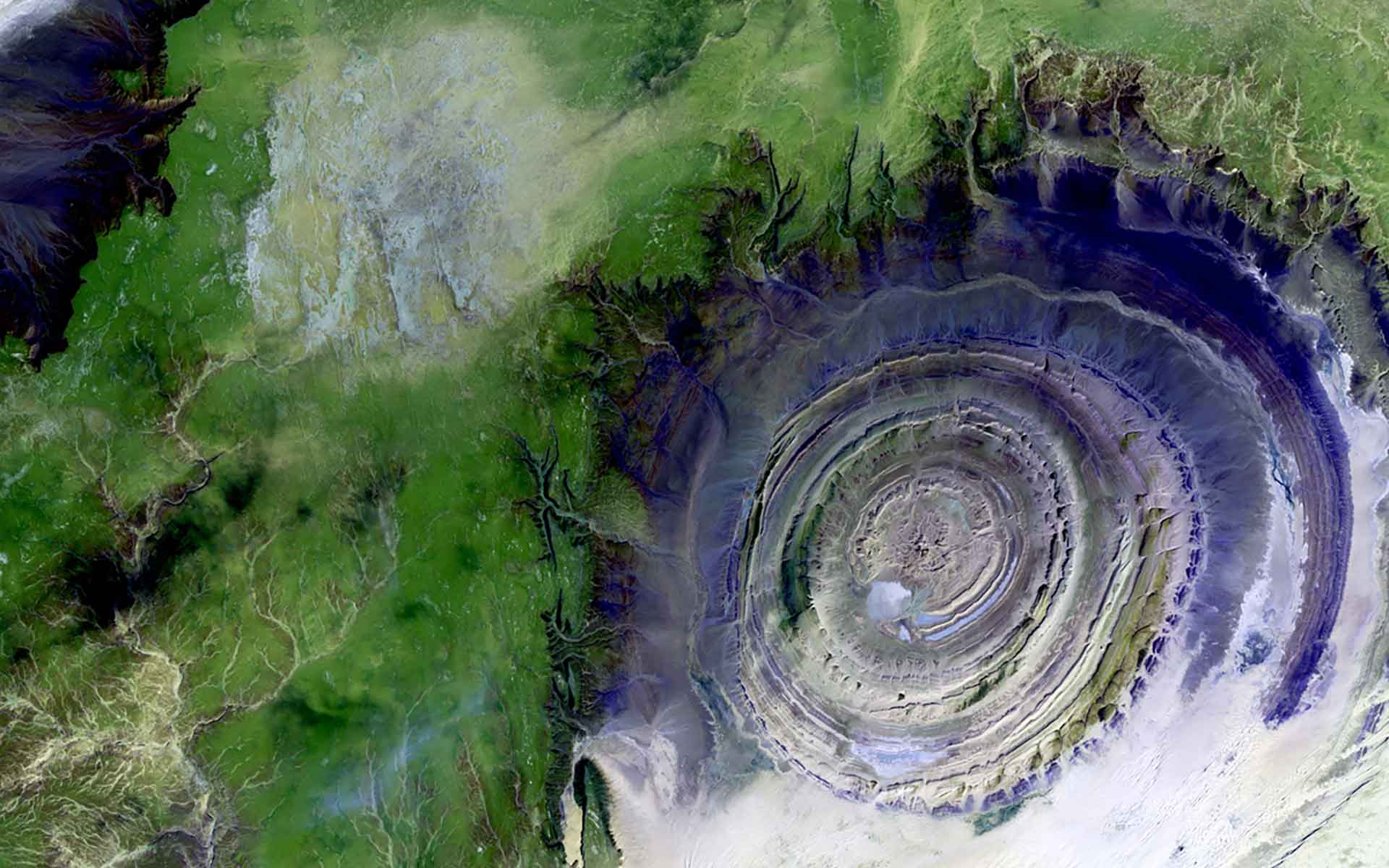
Aerial view of the Richat structure. (Photo: USGS en Unsplash).
The “Eye of Africa” Richat structure in the Saharan Desert is a spectacular example of a magmatic concentric Alkaline complex.
The Richat structure has been a case of scientific debate about the origin of ring structures in the world. There have been several studies to define whether it was an impact structure or intrusive feature. It is a case in point that shows serious scientific inquiry can lead to definite answers. It is one of the most spectacular examples of magma-induced ring structures in the world. It is aesthetically beautiful and unique geological feature whose outline is pronounced by the contrasting landscape of the wider Sahara Desert.
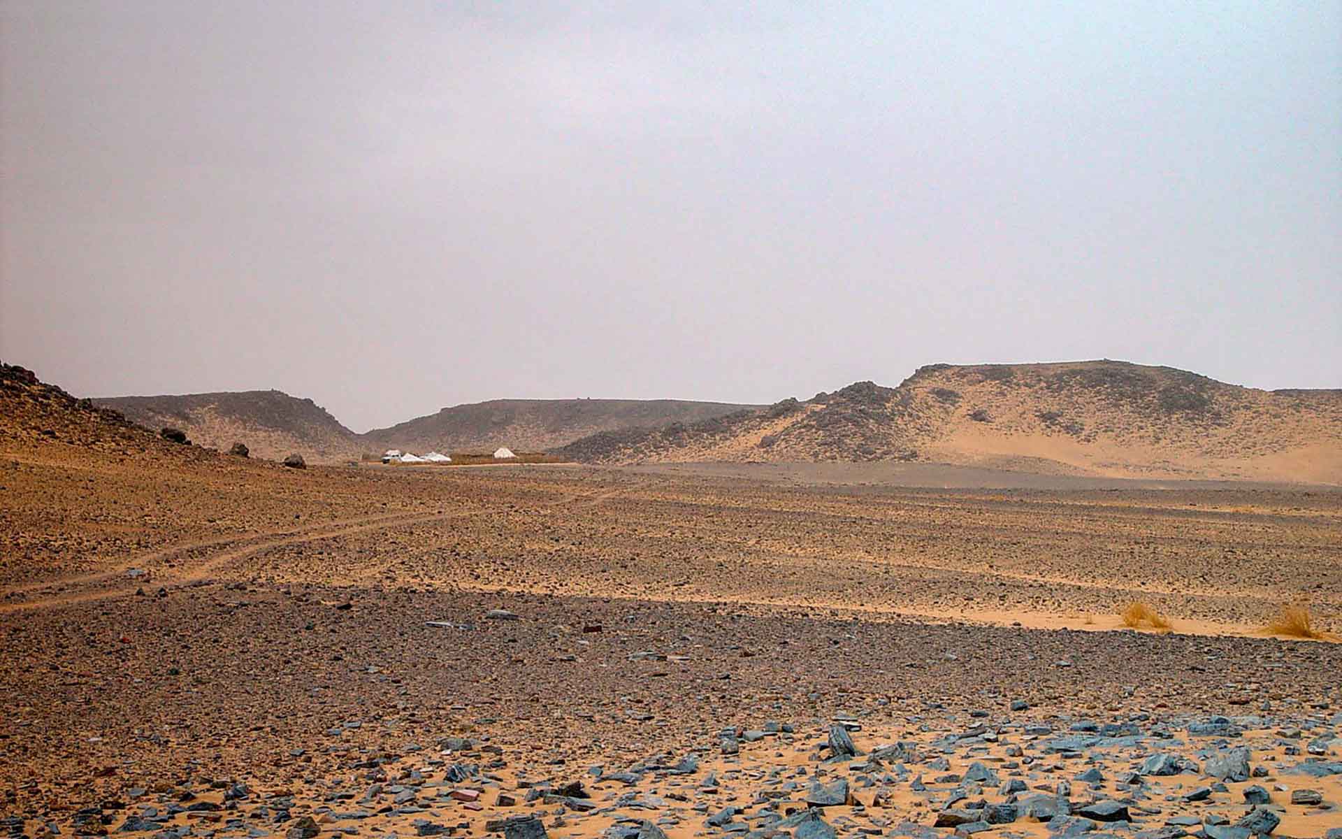
Photograph showing the very central section (Ombilic) of Richat Structure. (Photo: Michel Jebrak).
Geological description
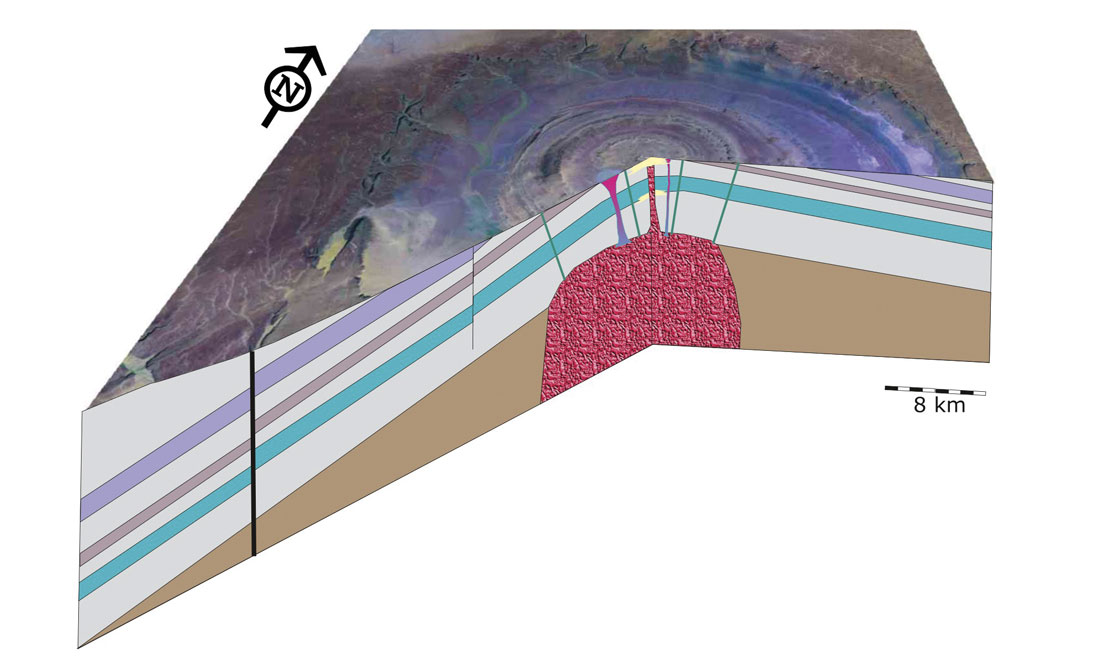
The circular structure of Richat is located in the northwestern part of the Taoudeni basin, in the central part of the Mauritanian Adrar plateaus, where it is expressed at the surface as a slightly elliptical depression, about 40 km in diameter, marked by concentric ridges of Proterozoic-Lower Paleozoic strata (O’Connor et al., 2004; Abdeina et al., 2021; Hamoud et al., 2021). The Richat structure appears as a large dome within a Late Proterozoic to Ordovician sequence, with circular cuestas represented by three nested rings dipping outward from the structure. The center of the structure consists of a limestone-dolomite shelf that encloses a kilometer-scale siliceous mega-breccia and is intruded by basaltic (gabbroic) ring dikes, kimberlitic intrusions, and alkaline volcanic rocks (Matton et al., 2005). Its origin has been enigmatic and debated with some suggesting that it was a meteoritic impact crater, which has been disproved in favour of an intrusion theory (Faudli 1969). The Richat is the superposition of a bimodal tholeiitic suite crosscut by carbonatitic (85 ± 5 Ma and 99 ± 5 Ma) and kimberlitic magmatic rocks (Matton and Jebrak, 2014). According to Abdeina et al. (2021) the gabbroic ring dykes represent deep magmatic structures connected to a large intrusive magmatic body.
Scientific research and tradition
The Richat circular structure has been studied since the 1950s when it was first identified from aerial photos with most of the debate focused on its origin. Recent works have ascertained its magmatic/ intrusive origin through various geological and geophysical studies including field-based investigations.
A 3D cross section of the Richat Structure showing magmatic processes at the origin of the complex (Matton and Jebrak, 2014).
Reference
Abdeina, E.H. et al. (2021) ‘Geophysical modelling of the deep structure of the Richat magmatic intrusion (northern Mauritania): insights into its kinematics of emplacement’, Arabian Journal of Geosciences, 14(22), p. 2315. Available at: https://doi.org/10.1007/s12517-021-08734-4.
Faudli, R.F. (1969) ‘Coesite from the Richat Dome, Mauritania: A Misidentification’, Science, 166(3902), pp. 228–230. Available at: https://doi.org/10.1126/science.166.3902.228.
Hamoud, A. et al. (2021) ‘Mauritanian Geological Resources: A Lever for Sustainable Regional Development via Geotourism’, International Journal of Geoheritage and Parks, 9, pp. 415–429. Available at: https://doi.org/10.2139/ssrn.3910266.
Matton, G. and Jébrak, M. (2014) ‘The “eye of Africa” (Richat dome, Mauritania): An isolated Cretaceous alkaline–hydrothermal complex’, Journal of African Earth Sciences, 97, pp. 109–124. Available at: https://doi.org/10.1016/j.jafrearsci.2014.04.006.
Matton, G., Jébrak, M. and Lee, J.K.W. (2005) ‘Resolving the Richat enigma: Doming and hydrothermal karstification above an alkaline complex’, Geology, 33(8), pp. 665–668. Available at: https://doi.org/10.1130/G21542AR.1.
O’Connor, E.A. et al. (2004) Rapport Administratif des cartes géologiques et gîtologiques à 1/200 000 et 1/500 000 du Nord-Ouest de la Mauritanie. Nouakchott: DMG, Ministère des Mines et de l’Industrie, p. 408.
Author(s)
Asfawossen Asrat
Botswana International University of Science and Technology, Palapye, Botswana