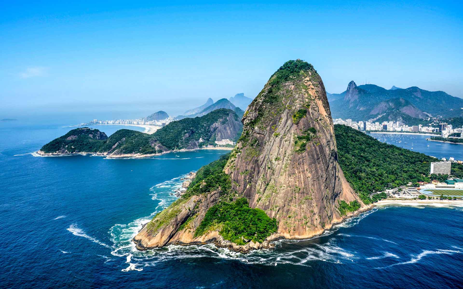
It is the ideal lookout for a stunning 360-degree view, giving the place invaluable educational importance for understanding landscape evolution (Alexandre Macieira | Riotur).
Geological Period
Neoproterozoic / Ediacaran
Main geological interest
Geomorphology and active geological processes
Tectonics
Location
Rio de Janeiro City, Rio de Janeiro State, Brazil.
22°56’59.0″S, 43°09’23.0″W
It is the ideal lookout for a stunning 360-degree view, giving the place invaluable educational importance for understanding landscape evolution (Alexandre Macieira | Riotur).
One of the most iconic rock monoliths in the world in an urban landscape.
Although more than 50 mountains are named “Sugar Loaf” (New Webster’s Dictionary and Thesaurus. Lexicon Publications, Danbury, Connecticut, 1993), the Sugar Loaf monolith is the world reference for this type of landform. The top of this outstanding pinnacle, easily reached by cable car, is the ideal lookout for the unique geomorphology of Rio de Janeiro (Silva and Ramos 2002) and the Serra do Mar range more to the north. It is also a cultural landmark because it has been a symbol of Brazil and of Rio de Janeiro in paintings and reports since the colonial period (Castro et al., 2021). It is part of a UNESCO World Heritage Site.
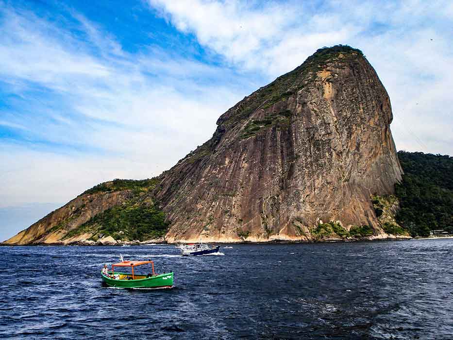
The type example of near-conical granite domes or bornhardts. Although accessible by difficult climbing routes, the summit is easely reachable by cable car.
Geological description
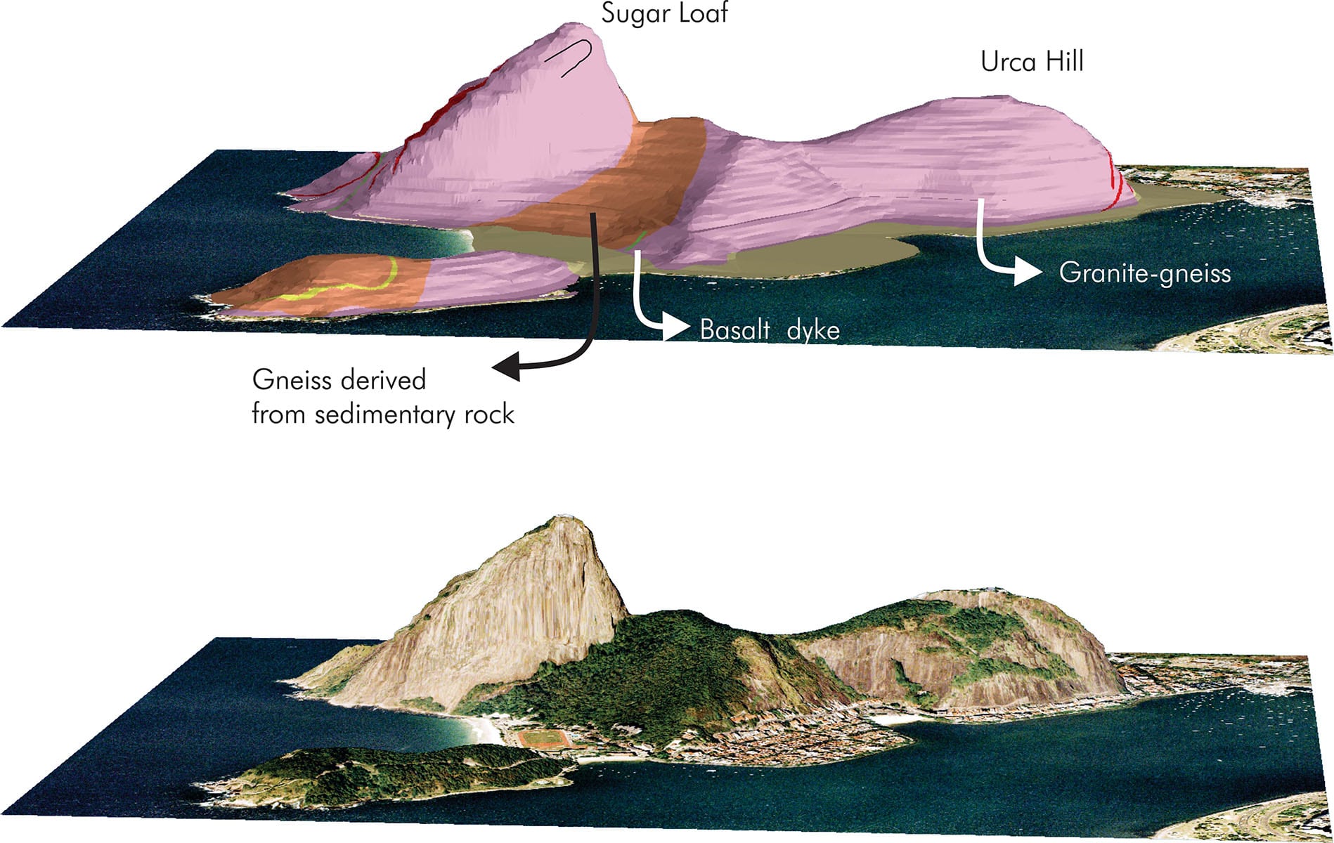
The Sugar Loaf (Pão de Açúcar, in Portuguese) is an outstanding 396 m high near-conical gneiss monolith located at the entrance of the Guanabara Bay, in Rio de Janeiro, SE Brazil. The Sugar Loaf is composed of an augen gneiss referred in local literature as the “Phacoid Gneiss” (from the Greek word for lens shaped). This gneiss is the product of metamorphism and deformation of a K-feldspar granite during the main collisional phase of the Ribeira orogenic belt at ca. 560 Ma (Ediacaran Period). Several isoclinal folds can be seen in the northern, southern and western sub-vertical faces (Valeriano et al., 2012).
Considering the geomorphological evolution of Sugar Loaf, the role of chemical alteration under the rainy tropical climate is evident. The metasedimentary gneiss was preferentially weathered and eroded, leaving the fresher augen gneiss making up the higher local relief. Steep ENE vertical fractures that affected the area during the Paleogene also control erosive processes that formed the sub-vertical south and north walls. At the southern wall a rock pillar, still attached to the main body, is a remnant of rockfall processes that shaped the monolith. Around the bottom of this pillar, an impressive boulder deposit represents debris from past rockfall events (Valeriano and Magalhães, 1984).
Scientific research and tradition
The Sugar Loaf is represented in maps as early as the 16th century when Europeans arrived in Brazil. One of the earliest map is from Jean de Léry (The singularities of the Antarctic France, 1572), where it was named “Pot de Beurre” by the French sailors, serving as the main reference for the entrance of the Guanabara Bay and Rio de Janeiro. In his famous voyage aboard the Beagle, Charles Darwin also pointed out the imposing presence of Sugar Loaf when he left Rio de Janeiro on the 8th of July 1832 (Chancellor and Wyhe, 2009).
Chemical alteration has preferentially weathered and eroded away the biotite-rich metasedimentary gneiss (forested area), leaving the fresher augengneiss making up the higher local relief.
Reference
Castro, N. et al. (2021) ‘A heritage stone of Rio de Janeiro (Brazil): the Facoidal gneiss’, Episodes, 44(1), pp. 59–74. Available at: https://doi.org/10.18814/EPIIUGS/2020/0200S13.
Da Silva, L.C. et al. (2003) ‘Zircon U-Pb Shrimp dating of the Serra Dos Órgäos and Rio De Janeiro Gneissic Granitic Suites: Implications for the (560 Ma) Brasiliano/Pan-African collage’, Revista Brasileira De Geosiencias, 33(2), pp. 237–244.
Silva, L.C.D. and Ramos, A.J.A. (2002) ‘Pão de Açúcar, RJ – Cartão Postal Geológico do Brasil’, in Sítios Geológicos e Paleontológicos do Brasil. Schobbenhaus C., Campos D.A., Queiroz E.T., Winge M., Berbert-Born M. (eds). Brasília: DNPM/CPRM, Comissão Brasileira de Sítios Geológicos e Paleobiológicos (SIGEP), pp. 263–268. Available at: http://sigep.cprm.gov.br/sitios.htm.
Valeriano, C. de M. et al. (2012) Geologia e recursos minerais da folha Baía de Guanabara SF.23-Z-B-IV, estado do Rio de Janeiro, escala 1:100.000. 1. ed. Belo Horizonte. CPRM-Serviço Geológico do Brasil / UERJ- Universidade do Estado do Rio de Janeiro. Available at: http://rigeo.cprm.gov.br/jspui/handle/doc/11375.
Valeriano, C. de M. and Magalhães, A.C. (1984) ‘Geologia estrutural de area do Pão de Açucar e adjacências, Rio de Janeiro, Brasil’, Anais da Academia Brasileira de Ciências, 56(3), pp. 295–304.
Author(s)
Kátia Leite Mansur
Federal University of Rio de Janeiro (UFRJ)
Claudio de Morisson Valeriano
Rio de Janeiro State University (UERJ)