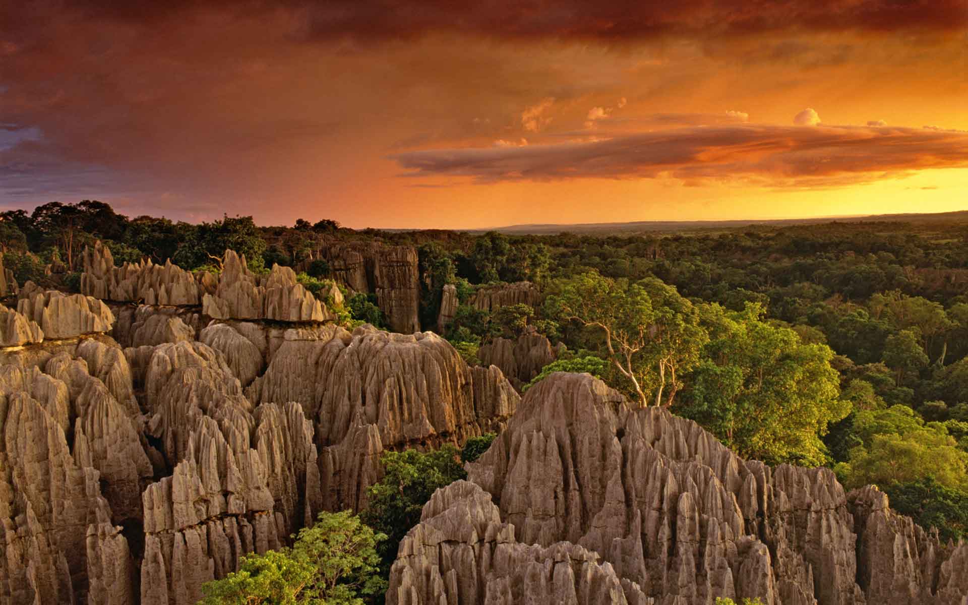
The spectacular limestone landscape of Bemahara is formed by sharp pinnacles, known in Malagasy language as Tsingy. (Copyright, Olivier Grunewald).
Geological Period
Pliocene – Holocene
Main geological interest
Geomorphology and active geological processes
Location
District d’Atsalova Région Melaky/ Madagascar.
18°12’00.0″S, 44°34’00.0″E
The spectacular limestone landscape of Bemahara is formed by sharp pinnacles, known in Malagasy language as Tsingy. (Copyright, Olivier Grunewald).
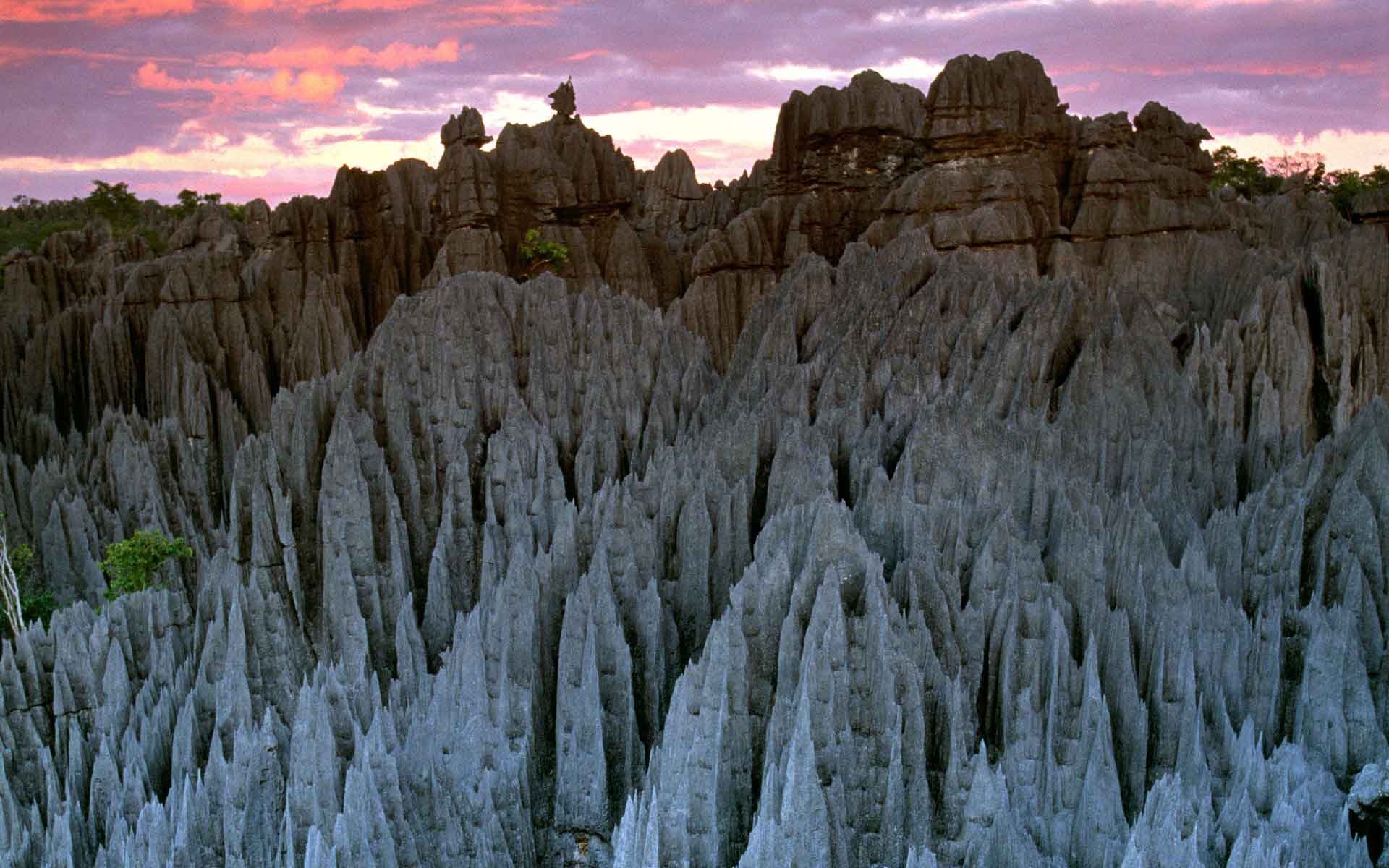
The Karstic landscape with”forest of shape stones” of exceptional beauty that gives its name to this geological feature.
The Bemaraha Tsingy represents rare and remarkable geological phenomena and are of exceptional beauty. The landscape is impressive. It is characterized by karst developed on a highly dissected limestone massif, which is crossed by a deep gorge. It is a spectacular expression of karstification and forms a “forest of sharp stones” with high limestone peaks rising 100 meters, forming veritable cathedrals and offering a grandiose, spectacular natural landscape. Further, “the Tsingy” of the limestone plateau forms an unusual feature of outstanding beauty, unique in the world, universally recognized by the effect created by the shades of forest green on metallic reflections of the grey karst “bristles”.
The top of the limestone massif shaped by centuries of erosion is made up of pungent and sharp rocks. (Copyright, Olivier Grunewald).
Geological description
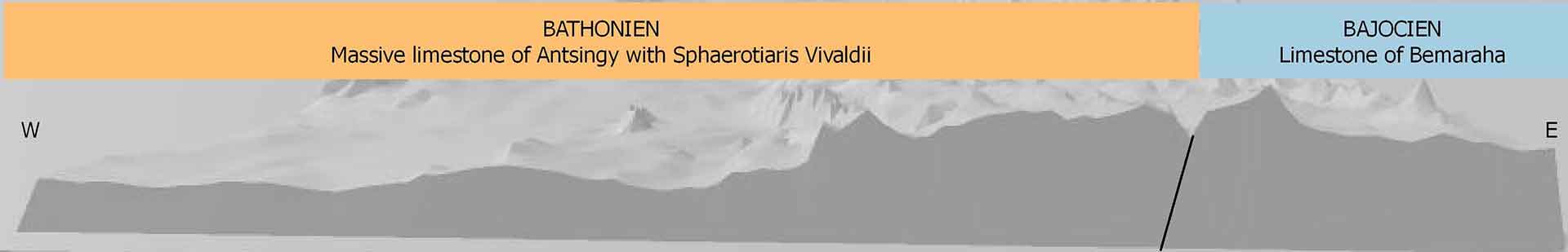
The Bemaraha Tsingy constitue a hill type karst developed on the surface of a 300- 500m thick Mesozoic Era, Middle Jurassic, Bajocian-Bathonian limestone sequence (Bésairies and Collignon, 1972). It relief varies from 100 m in the west to 600 m in the east, where it then drops 300-500 m to the Betsiriry Valley. The limestone is crossed by several large rivers, the Tsierbinia and manambolo. The latte has eroded a canyon 300 m deep (Dobrilla et al., 2006). The BemarahaTsingy is presented as a true cathedral of limestone. It is characterized by a dense network of faults, by crevasses, and by surfaces of limestone sculpted into blades and sharp needles.
The limestone formed as a deposit of fossil corals during the Middle Jurassic. The dissolution of carbonate rocks creates dolines and avens which act as a refuge for the green vegetation in the dry forest of the West. The limestone has a complex karst hydrology with the Tsingy servince as a water tower for the region of Antsalova.
Scientific research and tradition
The Bemaraha Tsingy has been studied the past 50 years. Investigations have focused on the caves and grikes. The Bemaraha Tsingy strict Nature reserve was listed as a UNESCO World Heritage Site in 1990.
Geological sketch or diagram showing the age and the formation in the Tsingy.
Reference
Besairie, H. and Collignon, M. (1972) ‘Géologie de MadagascarI. Les terrains sédimentaires’, Annales Géologiques de Madagascar, p. 463.
Dobrilla, J.C., Colney, F. and Delaty, J.-N. (2006) ‘Spéléologie sous les Tsingy de Bemaraha’, Spelunca. 5e série [Preprint].
Middleton, G. (1996) ‘The 1995 Australo-Anglo-MalagasySpeleo-Ornitho-Malacological Expedition: Tsingy de Bemaraha, Western Madagascar’, Journal of the Sydney Speleological Society, 40, pp. 141–158.
Middleton, G. (1998) ‘International Speleo-OrnithoGeo-Malacological Expedition: Northern Tsingy de Bemaraha, Western Madagascar’, Journal of the Sydney Speleological Society, 42, pp. 231–243.
Veress, M. et al. (2008) ‘The origin of the Bemaraha tsingy (Madagascar)’, International Journal of Speleology, 37(2). Available at: http://dx.doi.org/10.5038/1827-806X.37.2.6.
Author(s)
Voahanginiaina SAHOLIARIMANANA
Geologist Responsible for the Safeguarding of Geological and Mining Heritage at the Ministry of Mines, Madagascar