Namakdan Salt Cave

IRAN

One of the big halls of Namakdan Cave with untouched stalactites. (Photo: Philippe Crochet).

Geological Period

Cambrian

Main geological interest

Tectonics
Geomorphology and active geological processes

Location

Qeshm Island UNESCO Global Geopark / Hormozgan Province, Iran.
26°37’31.0″N 55°31’00.0″E

One of the big halls of Namakdan Cave with untouched stalactites. (Photo: Philippe Crochet).

One of the World’s longest salt caves inside an amazing salt dome, including the historical and cultural background.

This is one of the most unique salt caves in the world. It is 6.580m long and up to 40m wide. The discovered part of the cave is the longest salt cave known in the world. This Cave is considered the “key geosite” in Qeshm Island UNESCO Global Geopark. The remnants of historical sulphur and salt mining and trading are among the cultural values of this site. Namakdan is also on the tentative list of World Heritage Sites. For these reasons, the cave is under strict protection and preservation strictly

Namakdan Salt Cave in Salt Dome, 3N Entrance. (Photo: Phillippe Crochet).

The sedimentary succession of the Persian Gulf basin is warped and pierced by numerous salt diapirs of the basal Late Proterozoic Hormuz Series that was deposited in intracratonic basins formed during Late Proterozoic transtensional events after the Precambrian basement accretion. Namakdan salt diaper is among the most fascinating salt diapers (out of more than 250) in Iran. This diapir is composed of massive rock salt, anhydrite, fetid limestone, dark cherty dolomite, red sandstone, shale, and volcanic rocks. Marine, fluvial cave sediments and karst phenomena were studied and dated by 14C, U-series, and OSL methods to determine the evolution of the Namakdan diapir during the Holocene and the Last Glacial Period. Sea-level oscillations, the uplift rate of the diapir and its surroundings, and erosion are the main factors influencing the diapir morphology. Namakdan Salt Dome has a round shape with an area of about 38 km2 on the surface. Based on new geophysical data, the root of the salt dome originates at a depth of 20 km. This dome is located in the western part of the Salakh Anticline, and it has affected the western nose of the anticline. During uplift igneous, metamorphic, and sedimentary rocks have come up along with the salt as exotic blocks. Some features such as radial faults and rim syncline have been formed around the Namakdan Salt Dome.

The salt karst of the southern east of Iran (Zagros Mountains) was surveyed in the Namak Project (means salt in Farsi) by Czech-Iranian researchers. The project has two phases and the first research phase was done in 1998- 2000 and continued in the period 2005-2017. During this project, the salt dome of Qeshm Island was surveyed and mapped.

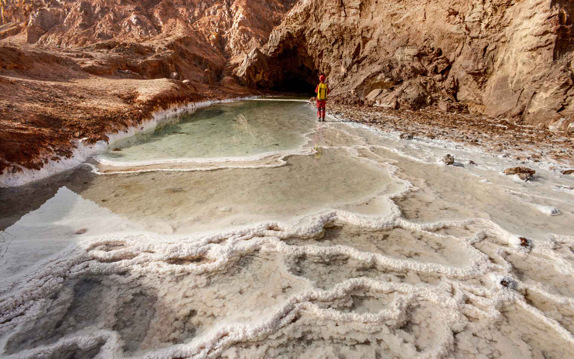
Bruthans, J. et al. (2005) ‘NAMAK: Czech-Iranian research project in Iranian salt karst (SE Zagros Mts.)’, in Czech Speleological Society 2001–2004. P. Bosák and Z. Motyčka. Prague: CSS, pp. 49–53.

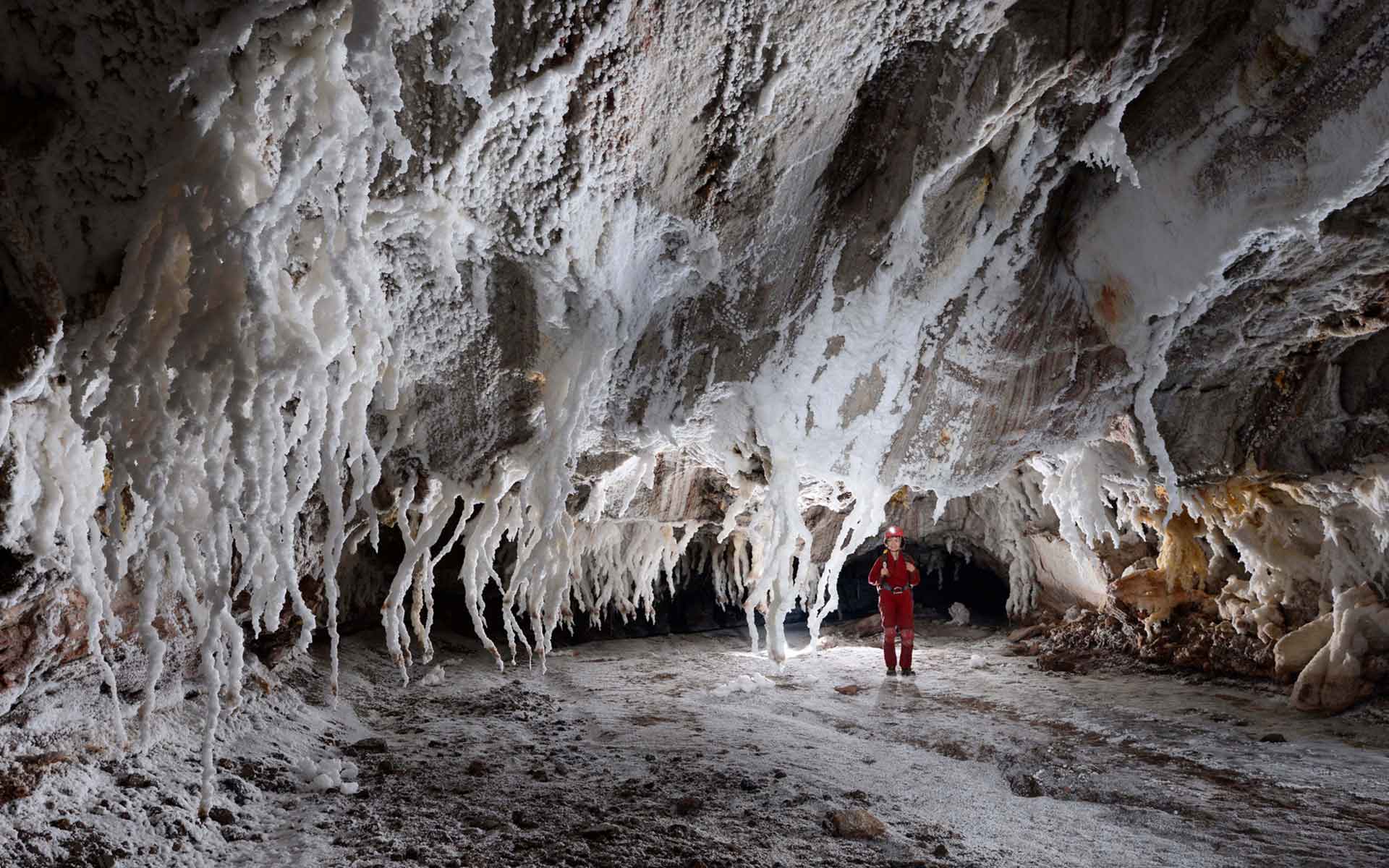
Bruthans, J., Filippi, M., et al. (2006) ‘3N Cave (6580 m): Longest salt cave in the world’, National Speleological Society, (64), p. 9.

Bruthans, J., Kamas, J., et al. (2006) ‘Holocene marine terraces on two salt diapirs in the Persian Gulf. Iran: age, depositional history and uplift rate’, Journal of quaternary science, 21, pp. 843–857.

Filippi, M. and Bruthans, J. (2009) ‘Czech-Iranian research in salt karst (SE Iran, Zagros Mts.): Project NAMAK in the period 2005–2008’, in Czech Speleological Society, 2001-2004.

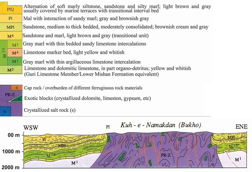
Hassanpour, J. et al. (2021) ‘Impact of salt layers interaction on the salt flow kinematics and diapirism in the Eastern Persian Gulf, Iran: Constraints from seismic interpretation, sequential restoration, and physical modelling’, Tectonophysics, 811, p. 228887. Available at: https://doi.org/10.1016/j.tecto.2021.228887.

Mukherjee, S., Talbot, C.J. and Koyi, H.A. (2010) ‘Viscosity estimates of salt in the Hormuz and Namakdan salt diapirs, Persian Gulf’, Geological Magazine, 147(4), pp. 497–507. Available at: https://doi.org/10.1017/S001675680999077X.

Shahpasandzadeh, M., Hashemifar, G. and Shafiei Bafti, A. (2016) ‘Structural evolution of the Namakdan salt diapir in the Zagros fold-thrust belt: The Persian Gulf, Iran’, in EGU General Assembly Conference Abstracts. Geological Research Abstracts, pp. EPSC2016-1226.

Alireza Amrikazemi
Director of Qeshm Island UNESCO Global Geopark & Member of the Scientific Committee of Lut Desert World Heritage Base

Saeed Afsari fard
Structural Geologist at National Iranian Oil Company

Abdolvahed Pehpouri
Expert at Qeshm Island UNESCO Global Geopark