Salt domes and glaciers of the Zagros Fold and Thrust Belt
Iran
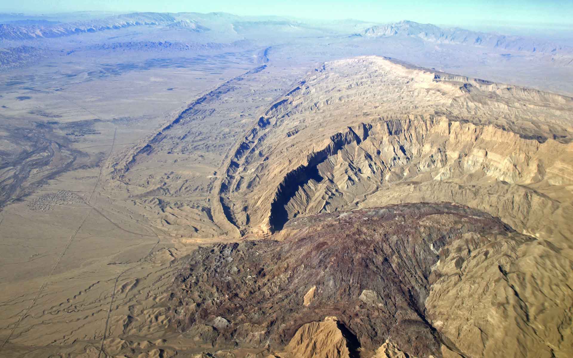
Ediacaran-Early Cambrian Hormuz salt extruded in the eroded core of a whale-back anticline of the Zagros mountain of southern Iran. The folded strata belong to Cretaceous to Pliocene sequence.
Geological Period
Neoproterozoic (Ediacaran) to Cambrian
Main geological interest
Tectonics
Geomorphology and active geological processes
Location
The outcrops are distributed in the Zagros Mountains in southern Iran and the Persian Gulf, Iran
27°18’11”N, 055°07’20”E
Ediacaran-Early Cambrian Hormuz salt extruded in the eroded core of a whale-back anticline of the Zagros mountain of southern Iran. The folded strata belong to Cretaceous to Pliocene sequence.
The most spectacular manifestation of salt tectonics in one of the youngest collisional zones in the world.
The Zagros fold and thrust belt hosts the most unique outcrops of the Neoproterozoic-Cambrian salts which have travelled up to 11 kilometers through their sedimentary overburden and have produced versatile beautiful salt domes and salt glaciers. No other continental (non-marine) salt domes, distributed in such a scale, may be found on the planet. The salt diapirism is accompanied by exclusive folded structures of young Zagros collisional belt. The fold and thrust belt hosts huge reserves of oil and gas and bears more than 200 salt domes mostly concentrated in the south of the belt.
Variegated landscape in the Tange-Zagh salt dome (IHormozgan Province) is formed through the exposure of salt, iron ore, and rock inclusions.
Geological description
The Zagros fold and thrust belt and the Persian Gulf foreland basin in southern Iran hosts a great number of emerged and buried salt domes, which root in the Hormuz series of Neoproterozoic-Cambrian age. The salt is associated with a mixture of gypsum, dolomite, and volcanic rocks (Faramarzi et al., 2015). This salt has risen through a thick overburden of sedimentary units (Talbot and Jarvis, 1984). The Hormuz series has played an important role in style of deformation and folding of the Zagros orogen following the collision between the Arabian and Iranian plates. The source of the evaporites is likely an oceanic system comparable to the present-day Red Sea (Omrani, unpublished data). The salt rises through vertical conduits to form salt domes and spreads on the ground as salt glaciers (namakiers). The first pulse of the diapiric movements was in the Mesozoic; however, major salt kinematics has occurred in more recent times in Cenozoic (Talbot, 1979; Ghassemi and Roustaei, 2021). Many hidden salt diapirs are detected in the seismic reflection profiles of Zagros and Persian Gulf. The Hormuz evaporites occur over a vast area of Iran, Middle East and Pakistan (Smith, 2015).
Scientific research and tradition
The very first paper in the first issue of the Journal of Structural Geology was published by Talbot (1979) on the Kuh-e-Namak (Dashti) in Iran, and since then the salt diapirs of the Zagros are used as the best natural labs for study of salt tectonics.
Satellite image of dozens of salt diapirs distributed in the southern part of Zagros Mountain Ranges.
Reference
Faramarzi, N.S. et al. (2015) ‘Geochronology and geochemistry of rhyolites from Hormuz Island, southern Iran: A new record of Cadomian arc magmatism in the Hormuz Formation’, Lithos, 236–237, pp. 203–211. Available at: https://doi.org/10.1016/j.lithos.2015.08.017.
Ghassemi, M.R. and Roustaei, M. (2021) ‘Salt extrusion kinematics: insights from existing data, morphology and InSAR modelling of the active emergent Anguru diapir in the Zagros fold and thrust belt, Iran’, Journal of the Geological Society, 178(6), pp. jgs2020-136. Available at: https://doi.org/10.1144/jgs2020-136.
Jahani, S. et al. (2007) ‘The Salt Diapirs of the Eastern Fars Province (Zagros, Iran): A Brief Outline of their Past and Present’, in O. Lacombe et al. (eds) Thrust Belts and Foreland Basins. Berlin, Heidelberg: Springer (Frontiers in Earth Sciences), pp. 289–308. Available at: https://doi.org/10.1007/978-3-540-69426-7_15.
Jahani, S. (2008) Tectonique salifère, plissement et fracturation dans les provinces du Fars Oriental et le domaine marin adjacent du Golfe Persique (Iran). Ph.D. Thesis. Cergy-Pontoise University.
Smith, A.G. (2012) ‘A review of the Ediacaran to Early Cambrian (“Infra-Cambrian”) evaporites and associated sediments of the Middle East’, Geological Society, London, Special Publications, 366(1), pp. 229–250. Available at: https://doi.org/10.1144/SP366.12.
Talbot, C.J. (1979) ‘Fold trains in a glacier of salt in southern Iran’, Journal of Structural Geology, 1(1), pp. 5–18. Available at: https://doi.org/10.1016/0191-8141(79)90017-8.
Author(s)
Mohammad R. Ghassemi.
Research Institute of Earth Sciences, Geological Survey of Iran.
Jafar Omrani.
Deputy of Geology, Geological Survey of Iran.
Alireza Amrikazemi.
Director of Qeshm Island UNESCO Global Geopark & Member of the Scientific Committee of Lut Desert World Heritage Base. Iran.