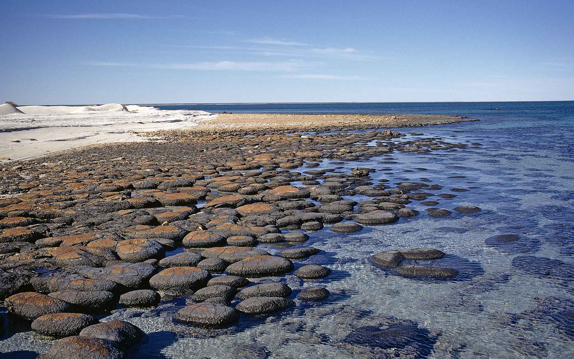
Stromatolite heads forming a coalesced reef-like body in southern Hamelin Pool (location shown in Figure).
Geological Period
Pleistocene to Holocene
Main geological interest
Stratigraphy and sedimentology
Geomorphology and active geological processes
Location
Gascogne Region, Western Australia, Australia
25°55’28”S, 113°48’17”E
Stromatolite heads forming a coalesced reef-like body in southern Hamelin Pool (location shown in Figure).
Shark Bay World Heritage site - an area of outstanding geological, geomorphological, and biodiversity values.
Of global geoheritage significance, Shark Bay is one of only a few World Heritage areas listed for all 4 outstanding natural values. The region is a globally important classroom for aspects of megascale coastal geomorphology, arid zone marine sedimentation, the interplay of sedimentation and coastal geomorphology with Quaternary tectonics, and smaller features such as stratigraphy, stromatolites, and crystal beds (Brocx and Semeniuk, 2007, 2010). The Shark Bay stromatolites are unique and globally important, providing valuable analogues of the early history of life on Earth. Geodiversity underpins the unique vegetation associations, and the region supports abundant marine flora and fauna.
- Geological description
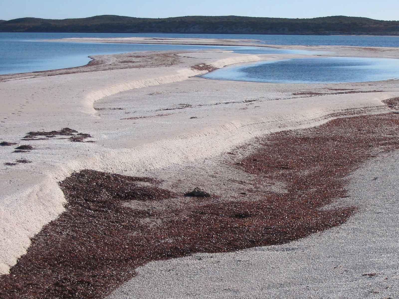
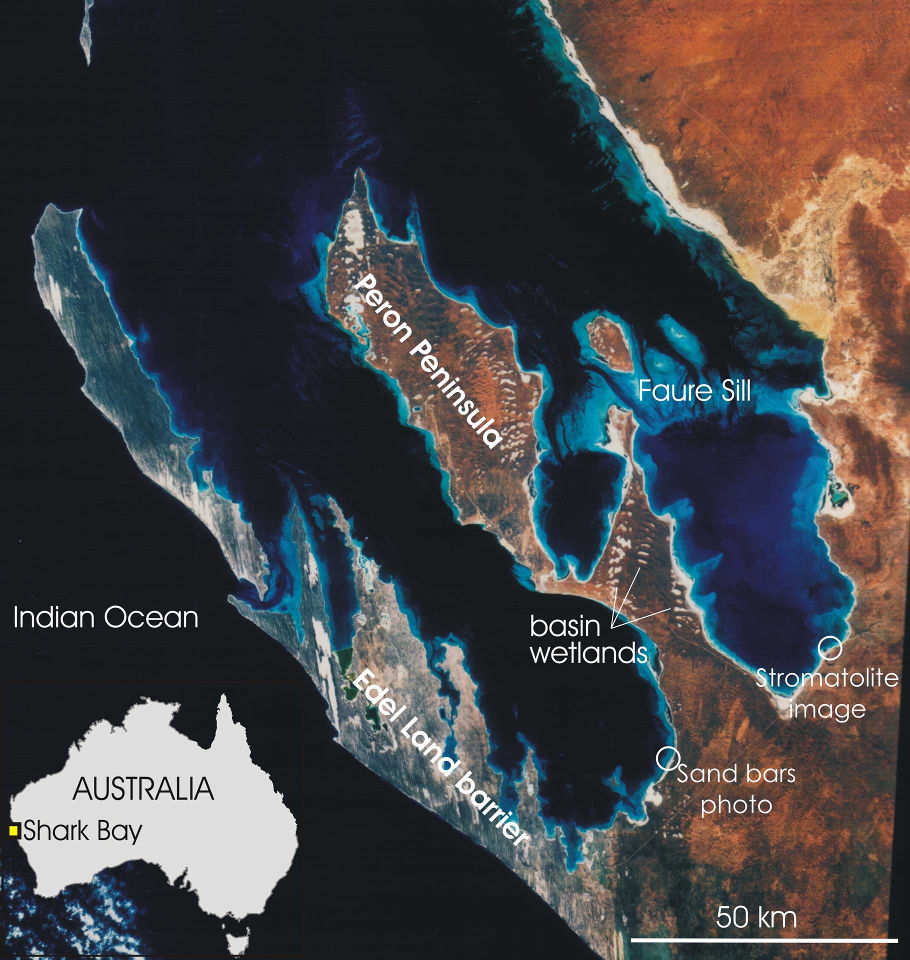
Shark Bay comprises large semi-enclosed elongate coastline-hugging twin embayments on the low-lying coast of the Indian Ocean on the most western point of Australia. Set in a climate with high evaporation, low rainfall, and strong southerly winds, Shark Bay is complex geomorphologically, sedimentologically, hydrochemically, and diagenetically. The embayments are framed by two Pleistocene linear barriers – a western limestone barrier (the Edel Land barrier), and an eastern red aeolian quartz sand peninsula (Peron Peninsula, a former barrier; see satellite image; Logan, 1970, 1974) that is studded with gypsum-filled wetland basins (birridas). Generally, these embayments have geomorphic units of a deep water basin, shoreline-fringing subtidal shallow-water platforms and/or seagrass banks, beaches, tidal flats, and beach ridges (Logan et al., 1970; Berry et al., 1990). Hydrochemically, Shark Bay borders oceanic water and, through evaporation, low circulation, and cross-embayment barriers, its salinity progressively grades southwards to metahaline and hypersaline. Where metahaline, embayments are fringed by shore-hugging seagrass banks, beaches, and shore-parallel spits (Photo, above). In the far southeast and separated by a cross-embayment barrier (the Faure Sill), Shark Bay becomes hypersaline – here are developed smaller embayments, ooid shoals and beach ridges, coquina sheets and beach ridges, tidal algal mats and stromatolites (stromatolite heads; Photo, previous page), tidal/supratidal gypsum crusts, subtidal to supratidal cemented carbonate crusts and pavements, and breccia sheets.
- Scientific research and tradition
Shark Bay has been investigated for its coastal features formed over thousands of years through a combination of sedimentation, erosion, and evaporation. These include marine stratigraphy, seagrass banks, coquina shores, tidal flat deposits, beaches, cliffs, dunes, and other features such as stromatolites, calcrete, limestone aeolian formations, and fossil shell banks.
Satellite photograph of Shark Bay showing the twin elongate northwest-oriented embayments, deep water basins (dark blue), shore-hugging shallow water sandy platforms (light blue), invaginated eastern shoreline and cliffed straight western shore of the western peninsula, wetland-rich nature of the eastern peninsula, and the submarine sill bisecting the eastern embayment.
- Reference
Berry, P.F., Bradshaw, S.D. and Wilson, B.R. (eds) (1990) Research in Shark Bay: report of the France-Australe Bicentenary expedition committee. Perth, W.A.: Western Australian Museum.
Brocx, M. and Semeniuk, V. (2007) ‘Geoheritage and geoconservation – History, definition, scope and scale’, Journal of the Royal Society of Western Australia, 90, pp. 53–87.
Brocx, M. and Semeniuk, V. (2010) ‘Coastal geoheritage: A hierarchical approach to classifying coastal types as a basis for identifying geodiversity and sites of significance in Western Australia’, Journal of the Royal Society of Western Australia, 93, pp. 81–113.
Logan, B.W. et al. (1970) Carbonate Sedimentation and Environments, Shark Bay, Western Australia. Tulsa, Oklahoma: American Association of Petroleum Geologists (Memoir 13). Available at: https://doi.org/10.1306/M13369.
Logan, B.W. et al. (1974) Evolution and Diagenesis of Quaternary Carbonate Sequences, Shark Bay, Western Australia. Tulsa, Oklahoma: American Association of Petroleum Geologists (Memoir 22). Available at: https://doi.org/10.1306/M22379.
Logan, B.W., Read, J.F. and Davies, G.R. (1970) ‘History of Carbonate Sedimentation, Quaternary Epoch, Shark Bay, Western Australia’, in B.W. Logan et al. (eds) Carbonate Sedimentation and Environments, Shark Bay, Western Australia. American Association of Petroleum Geologists, p. 0. Available at: https://doi.org/10.1306/M13369C2.
- Author(s)
Margaret Brocx.
Adjunct Professor of Research|College of Science, Health, Engineering and Education, Discipline Environmental and Conservation Sciences. Murdoch University, Western Australia, Australia.
Vic Semeniuk.
Adjunct Professor of Research|College of Science, Health, Engineering and Education, Discipline Environmental and Conservation Sciences. Murdoch University, Western Australia, Australia.

