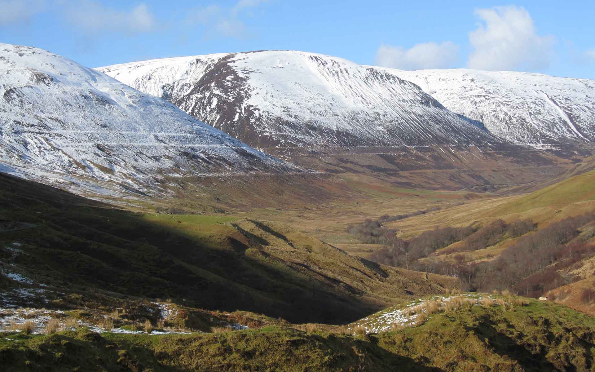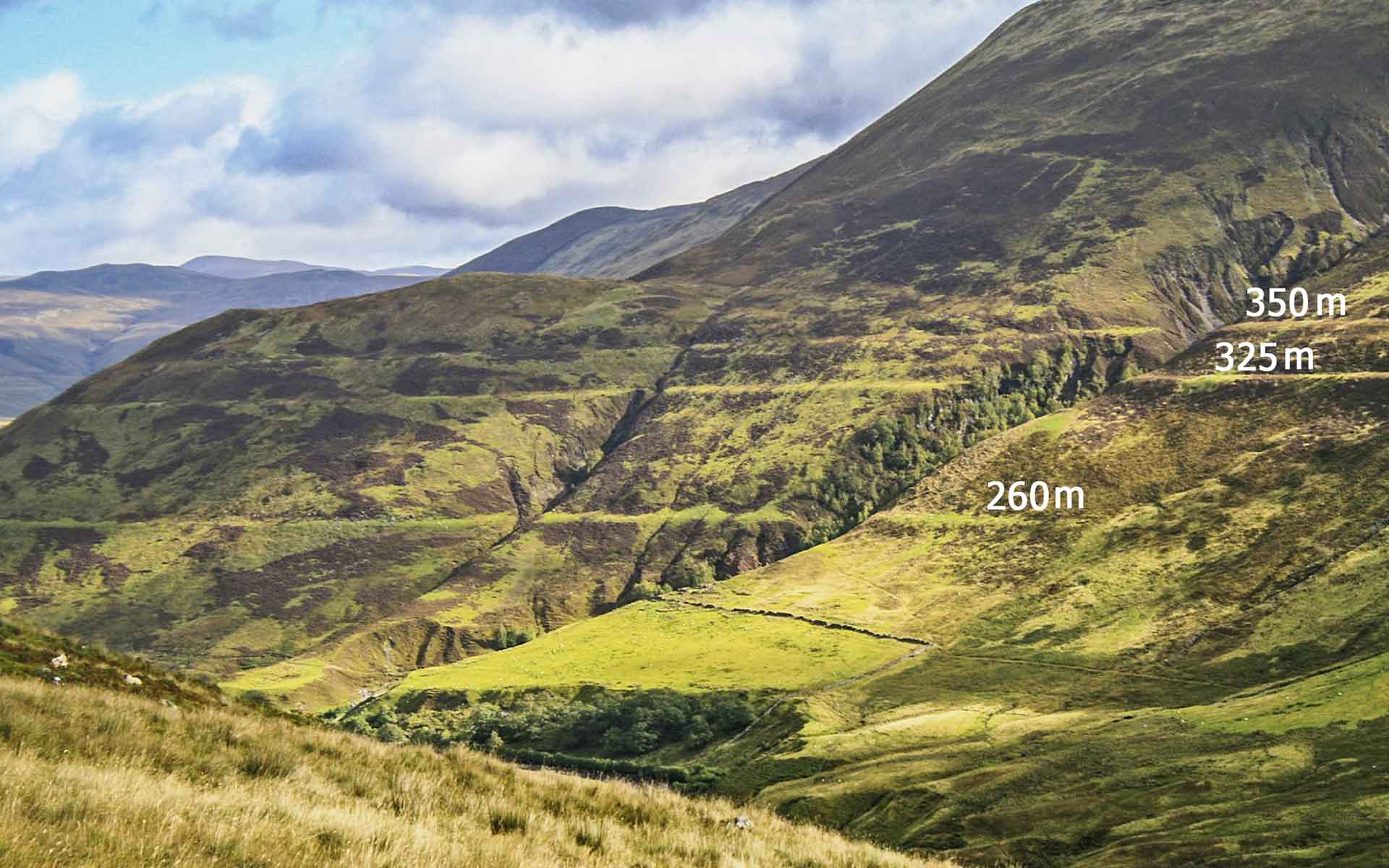
Classic view of the Parallel Roads of Glen Roy looking northwards from the Viewpoint area. The shorelines are at altitudes of 260m, 325m and 350m. (Photo: CC by 3.0 – Richard Crowest https://commons.wikimedia.org/wiki/File:Parallel_Roads.JPG).
Geological Period
Pleistocene
Main geological interest
History of geosciences
Geomorphology and active geological processes
Location
Lochaber, Scotland, United Kingdom
56°55’40”N, 004°47’54”W
Classic view of the Parallel Roads of Glen Roy looking northwards from the Viewpoint area. The shorelines are at altitudes of 260m, 325m and 350m. (Photo: CC by 3.0 – Richard Crowest https://commons.wikimedia.org/wiki/File:Parallel_Roads.JPG).
An iconic suite of glacial lake shorelines that underpinned the development of the Glacial Theory in the 19th century.
The Parallel Roads were fundamental in the development of the Glacial Theory (Agassiz, 1840). They provided convincing evidence for the former existence of glaciers in an area where none exist today, thus refuting the then-prevailing marine submergence theory of Darwin, Lyell and others, although Darwin later recognised his error and subsequently accepted the glacial interpretation (Rudwick, 2017). Since this pivotal contribution, research on the landforms, sediments and chronology of the area has played a major role in understanding the complexity, rapidity and trajectory of landscape evolution and environmental change at the end of the last glaciation (Palmer and Lowe, 2017).
- Geological description
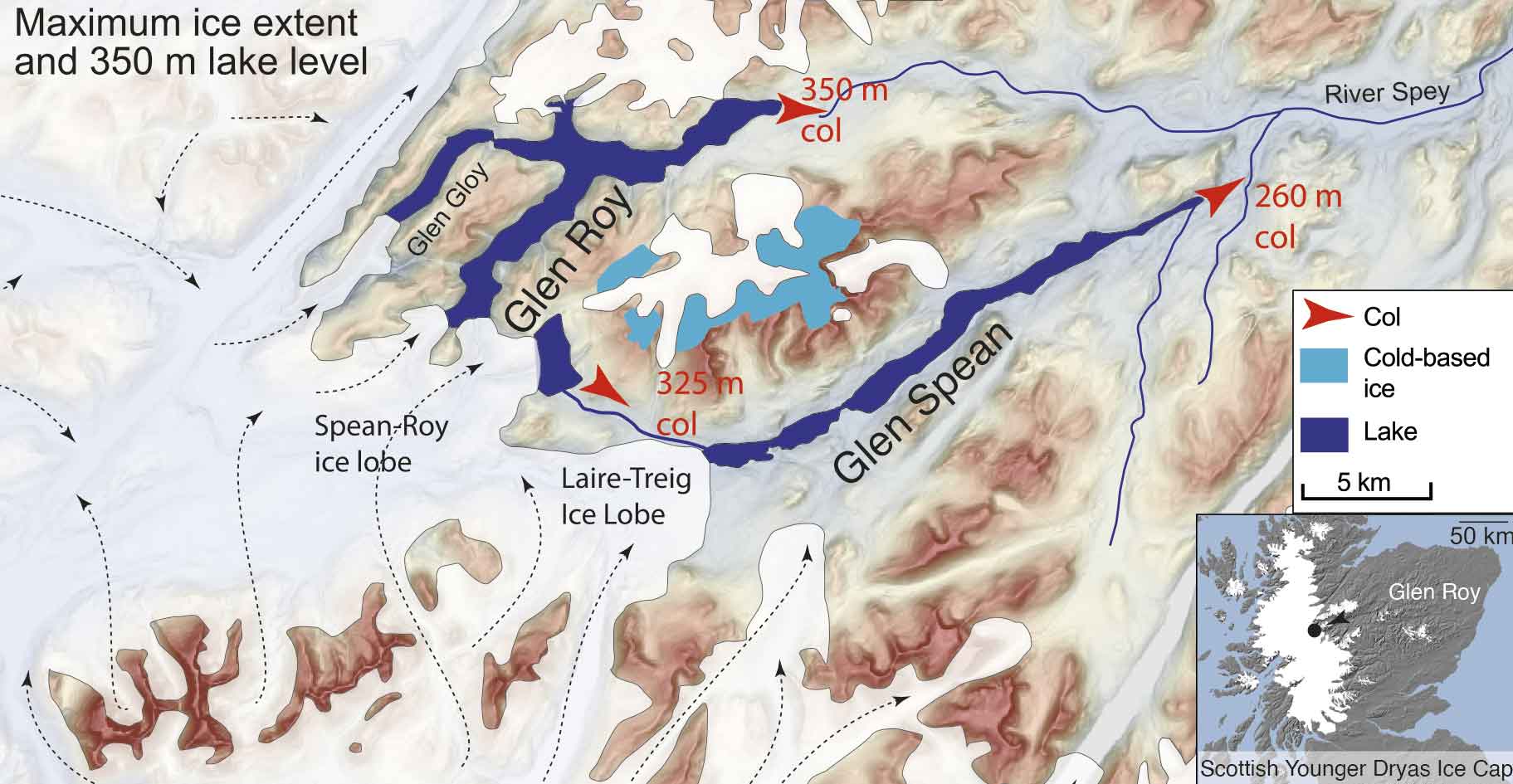
The landscape of the Western Grampian Highlands is dominated by the effects of geomorphological processes that operated during the Quaternary and especially during the Loch Lomond Stade (~Younger Dryas, ~12.9–11.7 ka) (Palmer and Lowe, 2017; Palmer, 2021). Particular highlights are three shorelines (‘Parallel Roads’) present along the flanks of Glen Roy at altitudes of 260m, 325m and 350m. Louis Agassiz visited Glen Roy in 1840 and, from comparison with similar landforms around modern glaciers in Switzerland, concluded that the Parallel Roads represent the shorelines of former ice-dammed lakes and not, as previously believed (e.g. by Charles Darwin and Charles Lyell), marine shorelines formed during a great submergence. The shorelines demonstrate that glaciers formerly existed in Scotland, providing compelling evidence for Agassiz’ theory of continental glaciation during a geologically recent Ice Age. The surface levels of the lakes were determined by those of overspill cols. Building on seminal work by J.B. Sissons during the 1970s and 1980s (Sissons, 2017), Palmer et al. (2020) developed a varve chronology which indicates that the lakes existed for 515 years between ~12.1 ka and ~11.6 ka. The area is a flagship geoheritage locality within the Great Britain Geological Conservation Review (Brazier et al., 2017).
- Scientific research and tradition
Glen Roy and Glen Spean have stimulated geological debate from the early-nineteenth century to the present day (Palmer and Lowe, 2017; Rudwick, 2017). They remain a research focus through analysis of annually resolved lake-sediment (varve) records to understand glacier dynamics at decadal scales using high-precision chronologies (Palmer et al., 2020).
- Reference
Agassiz, L. (1840) ‘On glaciers, and the evidence of their having once existed in Scotland, Ireland, and England’, in Proceedings of the Geological Society of London, pp. 327–332.
Brazier, V. et al. (2017) ‘The Parallel Roads of Glen Roy, Scotland: geoconservation history and challenges’, Proceedings of the Geologists’ Association, 128(1), pp. 151–162. Available at: https://doi.org/10.1016/j.pgeola.2016.11.008.
Palmer, A.P. et al. (2020) ‘A revised chronology for the growth and demise of Loch Lomond Readvance (‘Younger Dryas’) ice lobes in the Lochaber area, Scotland’, Quaternary Science Reviews, 248, p. 106548. Available at: https://doi.org/10.1016/j.quascirev.2020.106548.
Palmer, A.P. (2021) ‘Glen Roy and Glen Spean’, in C.K. Ballantyne and J.E. Gordon (eds) Landscapes and Landforms of Scotland. Cham: Springer International Publishing (World Geomorphological Landscapes), pp. 299–315. Available at: https://doi.org/10.1007/978-3-030-71246-4_16.
Palmer, A.P. and Lowe, J.J. (eds) (2017) ‘The Lateglacial and early Holocene of Glen Roy, Lochaber western Scottish Highlands. Dynamic responses to rapid climate change in a sensitive Highland landscape’, Special Issue. Proceedings of the Geologists’ Association, 128(1), p. 162. Available at: https://doi.org/10.1016/S0016-7878(17)30010-X.
Rudwick, M.J.S. (2017) ‘The origin of the Parallel Roads of Glen Roy: a review of 19th Century research’, Proceedings of the Geologists’ Association, 128(1), pp. 26–31. Available at: https://doi.org/10.1016/j.pgeola.2016.04.001.
Sissons, J.B. (2017) ‘The lateglacial lakes of Glens Roy, Spean and vicinity (Lochaber district, Scottish Highlands)’, Proceedings of the Geologists’ Association, 128(1), pp. 32–41. Available at: https://doi.org/10.1016/j.pgeola.2015.12.004.
- Author(s)
John E. Gordon.
University of St Andrews, Scotland, UK.
Adrian P. Palmer.
Royal Holloway University of London, England, UK.
J. John Lowe.
Royal Holloway University of London, England, UK.
Colin K. Ballantyne.
University of St Andrews, Scotland, UK.
James Rose.
Royal Holloway University of London, England, UK.

