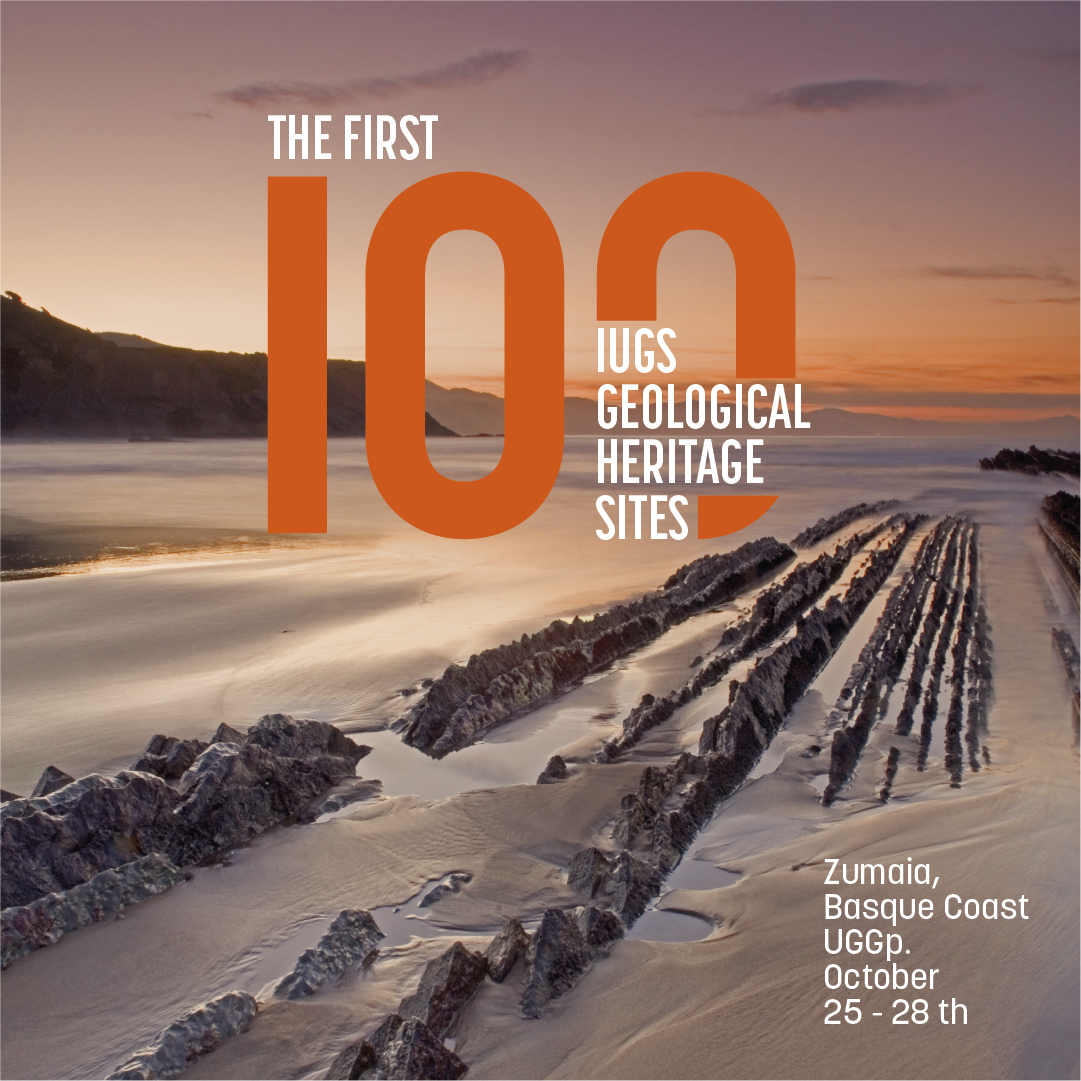
I think the numbers of this initiative speak for themselves. We have 100 sites recognised by the International Union of Geological Sciences in 56 different countries. To recognise these 100 sites, 186 sites were proposed and more than 400 experts from over 40 countries were involved in this project. I think this is a good sign of the credibility of the International Union of Geological Sciences and the credibility of this project.
Asier Hilario: President of the IUGS – International Commission on Geoheritage. Basque Coast UNESCO Global Geopark (UGGp).
As far as I am concerned, coordinating this project over the past year has been a very satisfying and demanding learning process. But it is hugely satisfying to have had the possibility of hitting the right key through the International Union of Geological Sciences to address a demand or an urge expressed by the geological community and which goes back many years. I’m very satisfied indeed.
I think it is important to point out that the geological community has had a long-standing urge to have its own programme for the recognition of its great sites, its major icons. There are various international recognitions to acknowledge geological sites, but the geological community needed to have a purely scientific programme, a non-institutional programme, a streamlined programme by which to recognise the key sites that have given rise to the fact that over the last 200 years we have been able to build this wonderful science that we are engaged in.
I believe that the announcement of the first 100 IUGS sites of geological interest represents the best of science in general, and, in particular, the geosciences and collaborative work. It is not possible to come up with a list of 100 sites and publish it openly all over the world, and be confident that this list has credibility, unless there has been a very long, laborious, very detailed process of keeping so many different partners from so many different countries, from so many different associations etc. aboard the same boat. So, I think the main significance is that the geological community, across many countries and different associations, has agreed to set up a project to give purely scientific recognition to the foremost sites of our science.
The International Union of Geological Sciences was established precisely 60 years ago with the aim of setting global standards for the geosciences. This means that geology is obviously starting to develop in different parts of the world because it is a basic need for society to progress, to know what resources it has on the Earth. But it is also natural to think that geology is pursued differently in China, Brazil, Europe or North America.
So, what became apparent 60 years ago was the need for an international body to set out the way of doing things, the way of unifying what is being done in different places so that we can all speak the same language. Let’s say that what it does is to set the standards by which geological science has to progress, in other words, to put the absolute truths of geology into a framework. The IUGS has different commissions and each of them deals with different issues, but the standards that are specified in each of the commissions are globally accepted ones.
Six years ago, the IUGS saw the need to position itself also in the field of geological heritage, because until about twenty years ago the concept of geological heritage was something that hardly existed, heritage was understood as everything that had to do with cultural heritage. However, understanding geological features as heritage means that as a society we attach value to them and therefore want to preserve them. It is a relatively new way of thinking, dating back some 20 years.
So in this area, the IUGS also sees the need or the possibility of opening a new commission and establishing the guidelines, the standards, the criteria by which this geological heritage of international importance is to be recognised. In fact, for some years now, it has been working with UNESCO to assess the quality of the geological heritage of Geoparks aspiring to World Heritage status.
We should protect geological heritage for the same reason that we should protect cultural heritage or biological heritage, because it makes us better people, it makes us a better society, it makes us show more respect towards what we have. Having said that, as a general reflection, the sites that represent geological heritage are heritage because we attach value to them, and if we attach value to them, it is because they have something to tell. Geological heritage sites are places that help us understand how the Earth system works. They are the places that help us understand how life or climate has functioned throughout history and are essential places to be able to calculate how we can address the main environmental challenges we will be facing in the coming decades. If we do not know what resources we have or how the system that sustains the Earth system works, we cannot plan any kind of environmental, social or land-use policy properly. We’re talking about huge challenges, such as the availability of water, new materials, minerals… And all this has an awful lot to do with geology, with knowledge of the substratum. So, recognising these sites and protecting them allows us to find out how the Earth system works out of a sheer intellectual appetite if we so wish, but also because we need to know how the system works in order to make proper progress.
When we began thinking about this programme, candidates came from different countries. For example, in the case of the main countries in Europe, they had the possibility of proposing four sites. A debate was then opened on their respective scientific forums to see which four would be proposed. This is one thing that got this project going. In the case of Spain too, obviously a debate was opened, led in this instance by the Spanish Geological and Mining Institute (IGME), and just as there were doubts about some sites, everyone agreed that one site simply had to be on the list: Zumaia.
Just looking at the bibliography underpinning it provides a little bit of information about the nature of this site: it is a site that has over 200 leading international papers published mainly over the last few decades, but also going back a long time, it has more than 20 PhD theses done here… According to experts, it is perhaps one of the most studied sites on the planet. And if that is so, there must be a reason. The main reason is that Zumaia probably represents the best site in the world to understand a specific period in the history of the Earth, more or less between 70 and 50 million years ago, during which very interesting, significant events took place, such as the extinction of the dinosaurs at the end of the Cretaceous Period or one of the greatest climate warming events in the history of the Earth 56 million years ago.
What made us lucky here was that we were under a tropical sea, which at that specific time was very calm; its sedimentation on the seabed captured, in tremendous detail, all those environmental changes that were occurring over those 20 million years. So, it must be the best book ever written about the history of the Earth or part of the history of the Earth. It is a book that is written in very good handwriting and which, what is more, because of the whole scientific tradition it has, geologists have known how to decipher the minerals, the fossils, the strata, the geometries… and convert them into knowledge. I remember once hearing Miguel Delibes say that for him this was a monument to the human capacity to think, because we had been able to turn layers of rock into the pages of a book that we can understand.
It seemed to us that the 60th anniversary of the International Union of Geological Sciences (IUGS) with such a key event as the presentation of the first 100 geological heritage sites, in which we are joined by the top leaders of the world’s major geological associations, was a good time to make a declaration. Apart from the event, it really is a moment in human history in which the geological community wants to present its vision. The Zumaia declaration is the vision signed mainly led by the IUGS but endorsed by the main geological associations across the world; it is the vision that the geological community has about the role of the Earth sciences regarding the way we have to address the challenges we have in the future: climate change, the biodiversity crisis, water availability and management, mineral availability and management, new resources or ecosystem degradation…
It also has to do with a commitment to basic research. Basic research in geology, and in any other science, is fundamental to understanding how the system works. When we understand how the system works, we can prevent, we can predict how it may react. This is done through basic research, which often has no direct impact. So it is also a commitment to basic research and a recognition through these 100 sites of geological heritage; to make it known that there are geological sites in the world that should remain sacrosanct, that have to be regarded as heritage, as a value, by humanity.
Zumaia is located within a UNESCO Global Geopark, the Basque Coast Geopark. Geoparks, in my opinion, are the best idea the geological community has come up with in recent decades. It is the idea of using the geological heritage of certain sites of international significance for local development. To ensure that this geological heritage can serve as a driving force for identity, as a support for economic development, and enable the people in this area to have a greater and better knowledge of what they have and appreciate it more. The global network of Geoparks is a set-up recognised by UNESCO and right now comprises 177 Geoparks spread across 46 different countries. Geoparks are essentially local development tools based on geological heritage, the memory of the Earth, but focused on people and the future of these areas.
An IUGS Global Geological Heritage site, on the other hand, is much simpler. It is the recognition of a specific site for its scientific value, a site of the highest international scientific relevance. In principle, there is no need for it to be protected or for there to be any kind of initiative relating to it. If the local institutions then want to take advantage of the scientific value of this site to set up a much more complex project, an integral regional development project, that is up to them. But, they are two different things.