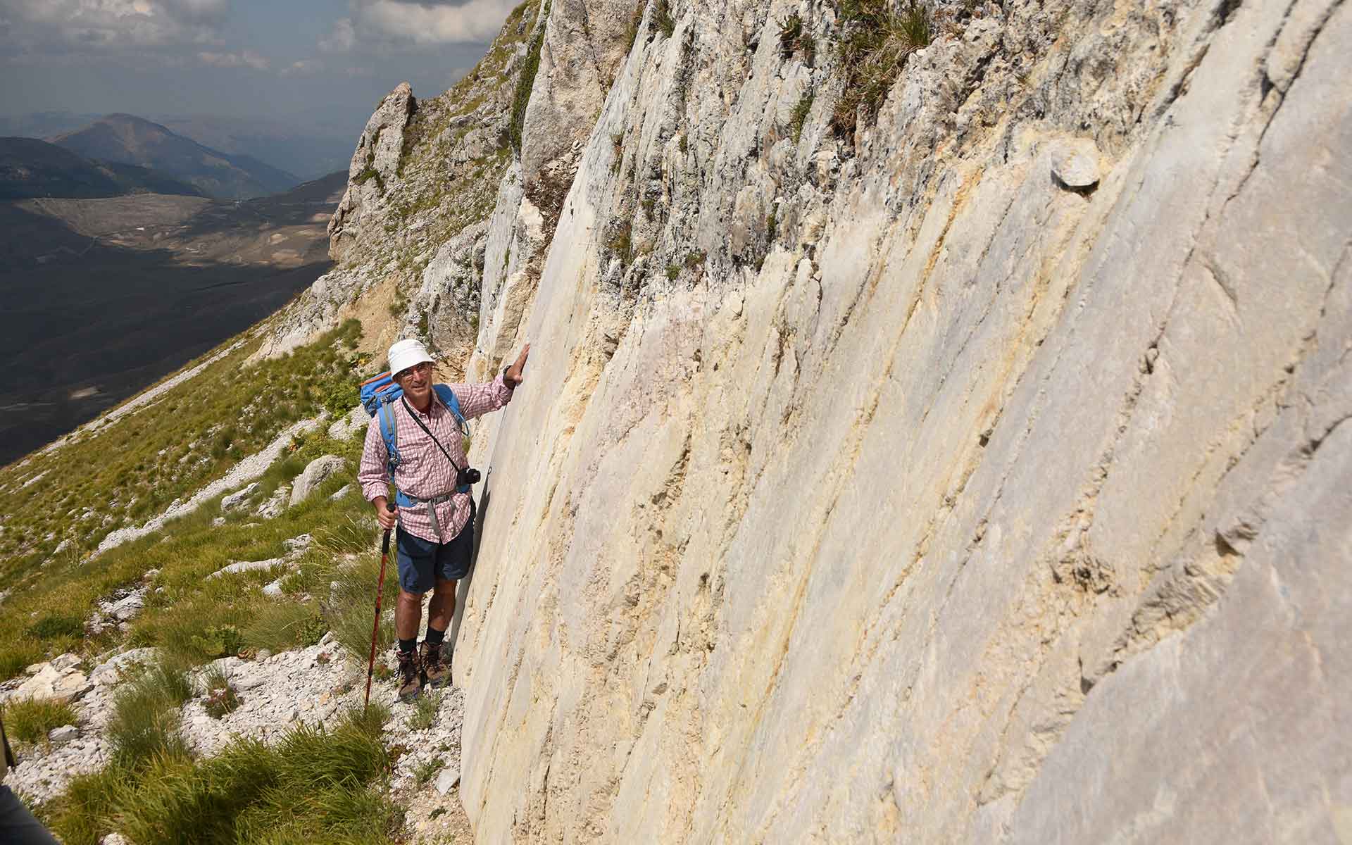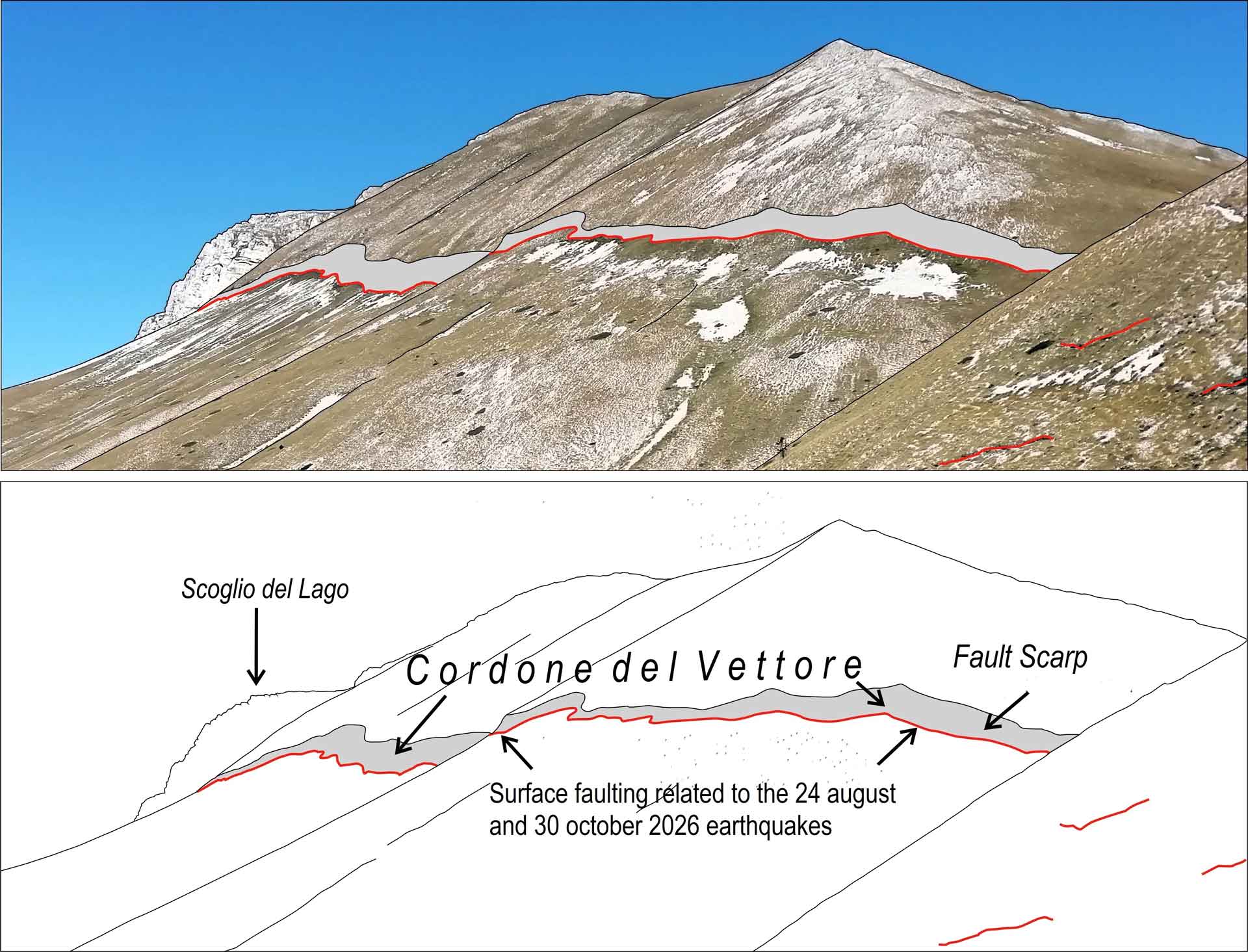
Mt Vettore, coseismic surface faulting associated with the earthquakes of 24th August and 30th October 2016, crossing the mountain from north to south.
Geological Period
Holocene
Main geological interest
Tectonics
Geomorphology and active geological processes
Location
Umbria-Marche, Italy
42°49’06”N, 013°15’10”E
Mt Vettore, coseismic surface faulting associated with the earthquakes of 24th August and 30th October 2016, crossing the mountain from north to south.
The most recent, documented and preserved surface faulting related to the 2016 earthquakes in Central Appennines.
Initiating in August 2016, a series of moderate to large earthquakes struck the central Apennines producing severe damage and 299 casualties in several small towns. Detailing all coseismic surface effects is crucial to identify and define primary surface faulting and its structural arrangement. This contributes to imaging the shallow-crust brittle deformation complexities and may provide useful information for describing the seismic source. Moreover, understanding the relations between the seismic source at depth and its evidence at the surface provides the basis for using the active faults at the surface to determine those faults that can rupture next.
- Geological description
Mt. Vettore is the peak of the Sibillini Mountains in central Italy. Its western slope is the morphological expression of a NNW-SSE striking SW dipping primary extensional tectonic element (the Mt. Vettore – Mt. Bove fault line, total length of 30 kilometeers), cutting through carbonates of the Umbria-Sabina Meso-Cenozoic succession for a total stratigraphic offset of about 1000 meters. The southern end of the fault was coseismically reactivated by the 2016 Central Italy seismic sequence. Here the slope is marked by at least two major Holocene bedrock fault scarps. The lower scarp runs at the base of the Vettore mountain front and bounds the Castelluccio basin. The upper scarp (visible from afar and locally known as “Cordone del Vettore”) runs very closely to the watershed. An approximately 2 meter high strip of whitish rock at the base of the Cordone del Vettore is the evidence of the dislocation along the fault plane due to the two main events (24th August, Mw 6.0 and 30th October 2016, Mw 6.5).
Due to its impressive structure and relatively recent formation, it represents a unique case within the National Geosite Inventory.
- Scientific research and tradition
The assessed primary surface faulting along the Mt. Vettore Fault is relevant to earthquake geology and paleoseismology, and therefore to seismic hazard assessment based on geological investigation. The ongoing studies will hopefully shed light on this matter of great relevance for reliable seismic hazard assessment.
- Reference
Calamita, F. and Pizzi, A. (1994) ‘Recent and active extensional tectonics in the southern Umbro-Marchean Apennines (central Italy)’, Memorie della Societa Geologica Italiana, 48, Part 2, pp. 541–548.
Civico, R. et al. (2018) ‘Surface ruptures following the 30 October 2016 Mw 6.5 Norcia earthquake, central Italy’, Journal of Maps, 14(2), pp. 151–160.
Galadini, F. and Galli, P. (2003) ‘Paleoseismology of silent faults in the Central Apennines (Italy): the Mt. Vettore and Laga Mts. Faults’, Annals of Geophysics, 46(5). Available at: https://doi.org/10.4401/ag-3457.
Galli, P. and Galadini, F. (1999) ‘Seismotectonic Framework of the 1997-1998 Umbria-Marche (Central Italy) Earthquakes’, Seismological Research Letters, 70(4), pp. 417–427. Available at: https://doi.org/10.1785/gssrl.70.4.417.
Livio, F.A. et al. (2016) ‘Surface faulting during the August 24, 2016, central Italy earthquake (Mw 6.0): preliminary results’, Annals of Geophysics, 59. Available at: https://doi.org/10.4401/ag-7197.
Pierantoni, P., Deiana, G. and Galdenzi, S. (2013) ‘Stratigraphic and structural features of the Sibillini Mountains (Umbria-Marche Apennines, Italy)’, Italian Journal of Geosciences, 132 (2013) f.3. Available at: https://doi.org/10.3301/IJG.2013.08.
Villani, F. et al. (2018) ‘A database of the coseismic effects following the 30 October 2016 Norcia earthquake in Central Italy’, Scientific Data, 5. Available at: http://dx.doi.org/10.1038/sdata.2018.49.
- Author(s)
Elisa Brustia.
ISPRA-Italian Geological Survey, Rome. Italy.
M. Cristina Giovagnoli.
ISPRA-Italian Geological Survey, Rome Italy.
Roberto Pompili.
ISPRA-Italian Geological Survey, Rome Italy.
Paolo Primerano.
ISPRA-Italian Geological Survey, Rome Italy.
Maurizio Piccini.
Geol. Sibillini National Park.

